%20--%3e%3cg%3e%3cg%20id='Layer_1'%3e%3cg%3e%3cg%3e%3cg%3e%3cg%3e%3cpath%20class='cls-1'%20d='M54.7,12.3c-1.4-1-3.3-1.6-5.5-1.6s-4.1.5-5.5,1.6c-1.7,1.2-2.5,2.9-2.5,5v11.8h5v-11.8c0-.4.1-.7.5-.9.6-.4,1.4-.6,2.6-.6s2,.2,2.6.6c.3.2.4.5.4.9v9.8c0,.5.2,1,.6,1.4.4.4.8.6,1.4.6h3v-11.8c0-2.1-.8-3.7-2.5-5Z'/%3e%3cpath%20class='cls-1'%20d='M75.4,11.1c-1,0-1.9.4-2.5,1.1-1.5-1.1-3.4-1.6-5.5-1.5s-4.4,1.1-6,2.7-2.7,4-2.7,6.5,1,4.9,2.7,6.7,4,2.7,6.6,2.7,3.4-.5,4.8-1.5c.6.7,1.4,1.1,2.5,1.1h1.7V11.1h-1.7ZM71.2,23.2c-.9.9-1.9,1.3-3.2,1.3s-2.3-.5-3.1-1.3-1.2-1.8-1.2-3,.4-2.3,1.2-3.1,1.9-1.3,3.1-1.3,2.2.4,3.1,1.3c.9.9,1.3,1.9,1.3,3.1s-.4,2.2-1.3,3.1h0Z'/%3e%3cpath%20class='cls-1'%20d='M89.5,10.7c-1.5,0-2.8.3-4,1v-6.8h-5v24.1h1.7c1,0,1.9-.4,2.5-1.1,1.5,1.1,3.2,1.6,5.2,1.5s4.7-1.1,6.3-2.8,2.7-4,2.7-6.5-.9-4.8-2.7-6.6c-1.8-1.8-4-2.7-6.6-2.7ZM92.6,23.2c-.9.9-1.9,1.3-3.1,1.3s-2.3-.5-3.1-1.3-1.3-1.9-1.3-3.1.5-2.3,1.3-3.1,1.9-1.3,3.1-1.3,2.3.5,3.1,1.3,1.3,1.9,1.3,3.1-.5,2.3-1.3,3.1Z'/%3e%3cpath%20class='cls-1'%20d='M116.3,11.1c-1,0-1.9.4-2.5,1.1-1.5-1.1-3.4-1.6-5.5-1.5s-4.4,1.1-6,2.7-2.7,4-2.7,6.5,1,4.9,2.7,6.7,4,2.7,6.6,2.7,3.4-.5,4.8-1.5c.6.7,1.4,1.1,2.5,1.1h1.7V11.1h-1.7ZM112.1,23.2c-.9.9-1.9,1.3-3.2,1.3s-2.3-.5-3.1-1.3-1.2-1.8-1.2-3,.4-2.3,1.2-3.1,1.9-1.3,3.1-1.3,2.2.4,3.1,1.3c.9.9,1.3,1.9,1.3,3.1s-.4,2.2-1.3,3.1h0Z'/%3e%3cpath%20class='cls-1'%20d='M157.2,11.1c-1,0-1.9.4-2.5,1.1-1.5-1.1-3.4-1.6-5.5-1.5s-4.4,1.1-6,2.7c-1.8,1.8-2.7,4-2.7,6.5s1,4.9,2.7,6.7,4,2.7,6.6,2.7,3.4-.5,4.8-1.5c.6.7,1.4,1.1,2.5,1.1h1.7V11.1h-1.7ZM153,23.2c-.9.9-1.9,1.3-3.2,1.3s-2.3-.5-3.1-1.3-1.2-1.8-1.2-3,.4-2.3,1.2-3.1,1.9-1.3,3.1-1.3,2.2.4,3.1,1.3c.9.9,1.3,1.9,1.3,3.1s-.4,2.2-1.3,3.1h0Z'/%3e%3cpath%20class='cls-1'%20d='M164.6,10.6c.8,0,1.5-.3,2.1-.9.6-.6.9-1.3.9-2.1s-.3-1.5-.9-2.1c-.6-.6-1.3-.9-2.1-.9s-1.5.3-2.1.9c-.6.6-.9,1.3-.9,2.1s.3,1.5.9,2.1c.6.6,1.3.9,2.1.9Z'/%3e%3c/g%3e%3cpath%20class='cls-1'%20d='M130.2,24c0,0-.2,0-.2.1-.3.2-1.8.3-2.3.3s-1.1-.1-1.4-.4c-.2-.2-.3-.6-.3-1.2v-6.8h2.4c.5,0,1-.2,1.4-.6.4-.4.6-.8.6-1.4v-3h-4.3v-1.6c0-.5-.1-1-.4-1.4-.7-1.1-1.7-1.6-2.8-1.6h-1.7v16.4c0,1.9.6,3.5,1.9,4.7,1.2,1.2,2.8,1.8,4.8,1.8s1.8,0,2.6-.2v-5.3Z'/%3e%3c/g%3e%3crect%20class='cls-1'%20x='162'%20y='11.6'%20width='5'%20height='17.6'/%3e%3cpath%20class='cls-1'%20d='M139.6,26.1c0,1.8-1.5,3.3-3.3,3.3s-2.6-.2-2.8-.2c0,0-.5-2.2-.5-3.1,0-1.8,1.5-3.3,3.3-3.3s2.8.1,3,.4c.2.4.4,2,.4,3Z'/%3e%3c/g%3e%3cpath%20class='cls-1'%20d='M29.3,17.5c-1.9,0-3.5,1.3-3.9,3h-.3c-2.8,0-5.3,1.2-7,3.1v-4.9c0-3.3.5-4.5,3.2-4.6.5,1.6,2,2.7,3.8,2.7s4-1.8,4-4-1.8-4-4-4-3.3,1.2-3.8,2.9c-1.3,0-2.3.3-3.1.7v-4.6c1.6-.5,2.7-2,2.7-3.8S19,.2,16.8.2s-4,1.8-4,4,1.2,3.3,2.9,3.8v4.6c-.8-.5-1.9-.7-3.3-.8-.5-1.7-2-2.9-3.8-2.9s-4,1.8-4,4,1.8,4,4,4,3.2-1.1,3.8-2.7c0,0,0,0,0,0,2.8,0,3.3,1.1,3.3,4.6v4.9c-1.7-1.9-4.2-3.1-7-3.1h-.7c-.4-1.7-2-3-3.9-3S0,19.3,0,21.5s1.8,4,4,4,3.1-1,3.7-2.5h.9c3.9,0,7,3.1,7,7v1.6h-4.2c-.7,0-1.2.5-1.2,1.2s.5,1.2,1.2,1.2h10.9c.7,0,1.2-.5,1.2-1.2s-.5-1.2-1.2-1.2h-4.2v-1.6c0-3.9,3.2-7,7-7h.5c.6,1.5,2,2.5,3.7,2.5s4-1.8,4-4-1.8-4-4-4ZM25,11.4c.9,0,1.6.7,1.6,1.6s-.7,1.6-1.6,1.6-1.6-.7-1.6-1.6.7-1.6,1.6-1.6ZM8.6,14.5c-.9,0-1.6-.7-1.6-1.6s.7-1.6,1.6-1.6,1.6.7,1.6,1.6-.7,1.6-1.6,1.6ZM4.1,23.1c-.9,0-1.6-.7-1.6-1.6s.7-1.6,1.6-1.6,1.6.7,1.6,1.6-.7,1.6-1.6,1.6ZM16.8,5.7c-.9,0-1.6-.7-1.6-1.6s.7-1.6,1.6-1.6,1.6.7,1.6,1.6-.7,1.6-1.6,1.6ZM29.3,23.1s0,0,0,0c0,0,0,0,0,0,0,0-.1,0-.2,0,0,0,0,0,0,0-.8-.1-1.3-.8-1.3-1.5s.6-1.5,1.4-1.6c0,0,0,0,0,0,0,0,0,0,0,0s0,0,0,0c0,0,0,0,0,0,.9,0,1.6.7,1.6,1.6s-.7,1.6-1.6,1.6Z'/%3e%3c/g%3e%3c/g%3e%3c/g%3e%3c/svg%3e)
Nabat is building the operating system for nature.
An end-to end AI platform to restore and manage the planet's most critical ecosystems at scale.
Nature is the planet's most critical infrastructure. Yet it has no standard operating system. Nabat is building it.
Coastal and dryland ecosystems are massive carbon sinks,
protect inhabited coastlines, and underpin critical food systems - yet are
dangerously undermanaged & underserved today.
Nabat changes that.
Coastal
7M ha of mangrove ecosystems are at risk of collapse by 2050. That is 50% globally.
Arid
1B ha of dry lands are degraded. That is 10-20% globally.
NabatOS
A complete AI-powered ecosystem management platform, that supports the full journey of government environmental agencies, corporate ESGs, project developers, and nature investors.
From accurate data to scalable action, to verified outcomes.
NabatOS pipeline
Manages ecosystems from data capture to verified outcomes.
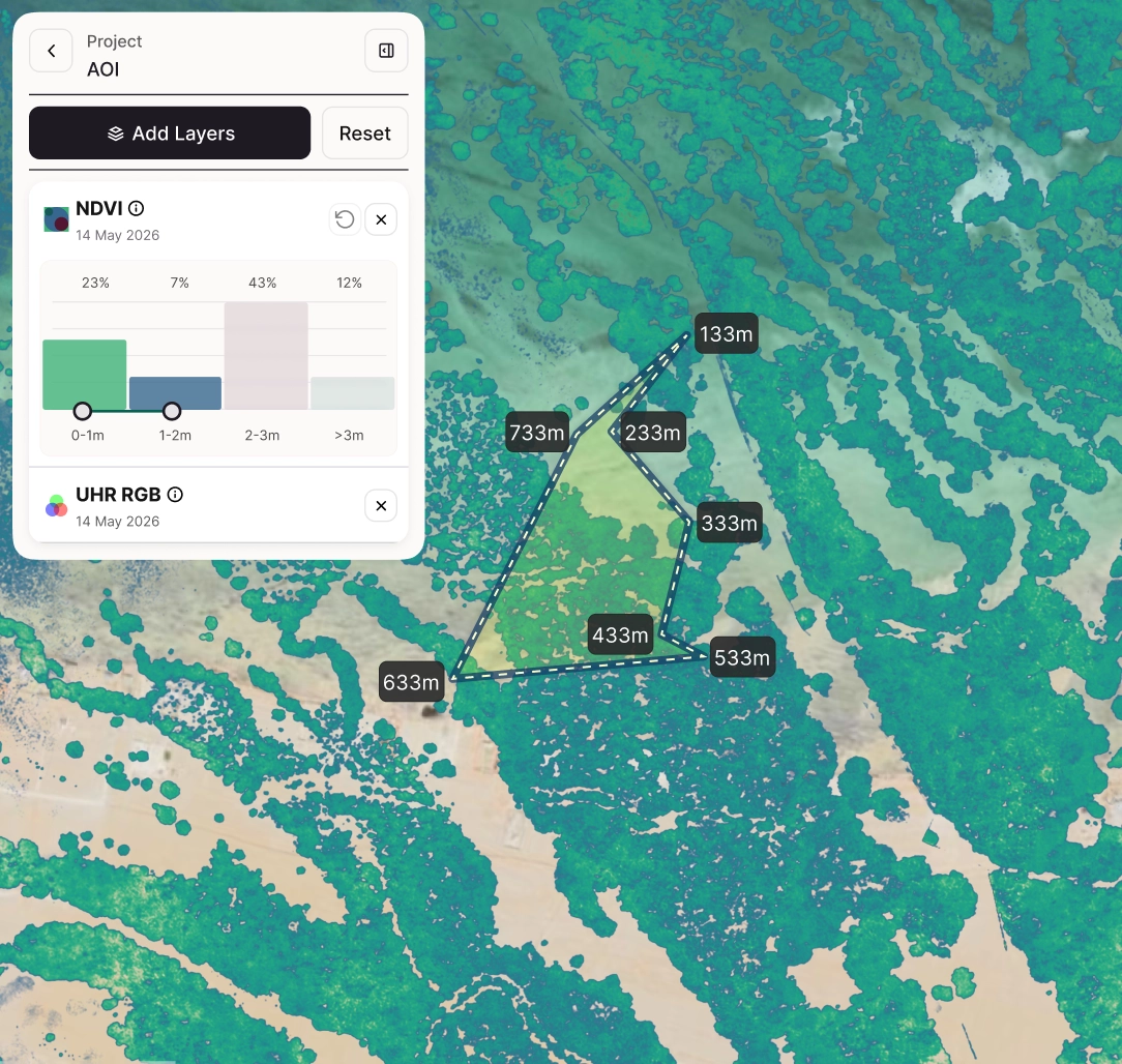
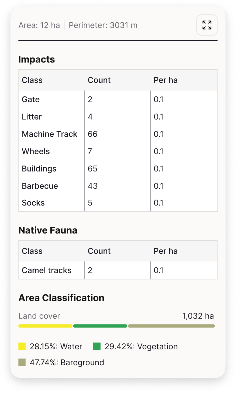
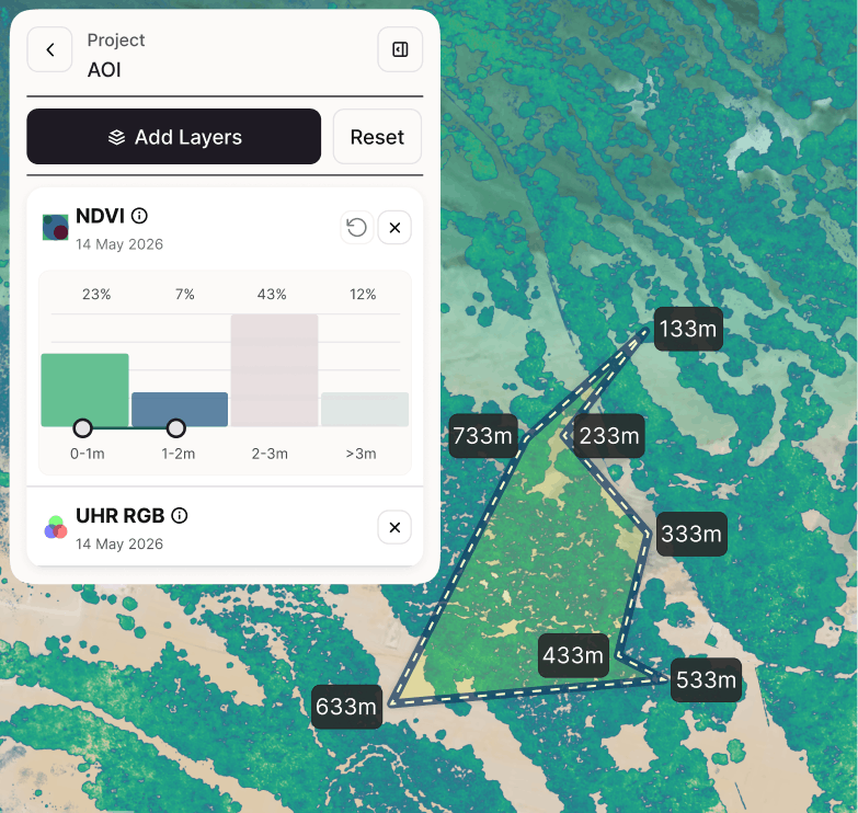
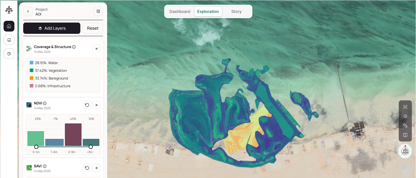
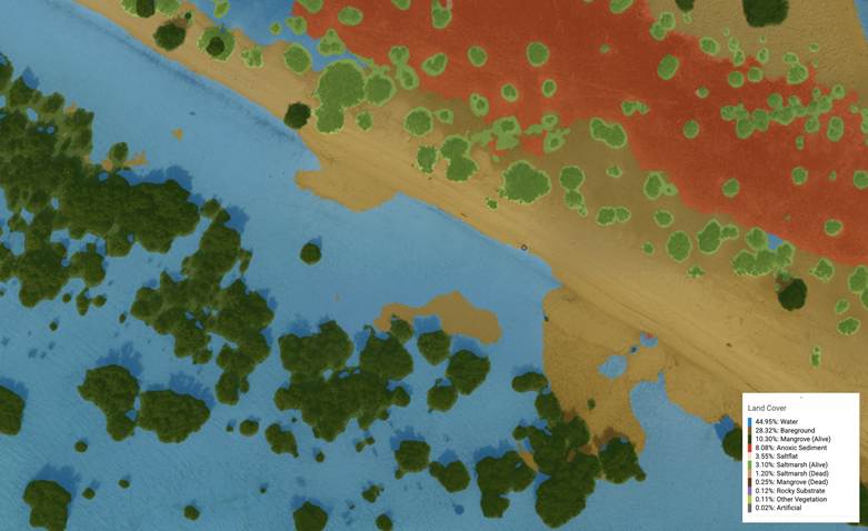
Map
Multi-sensor acquisition: survey drones, satellites, field sensors, LiDAR, SAR, optical. mm-resolution aerial and marine coverage. Data ingested directly into NabatOS for Ether-powered analysis.
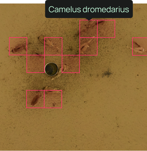
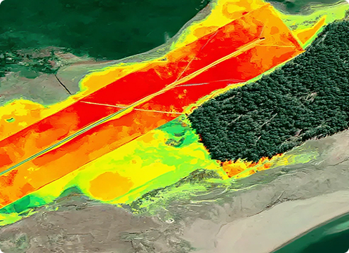
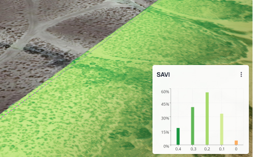
Assess
Ether-powered habitat intelligence: land cover classification, species identification, canopy structure, biomass estimation, and health scoring — across the full site at scale.
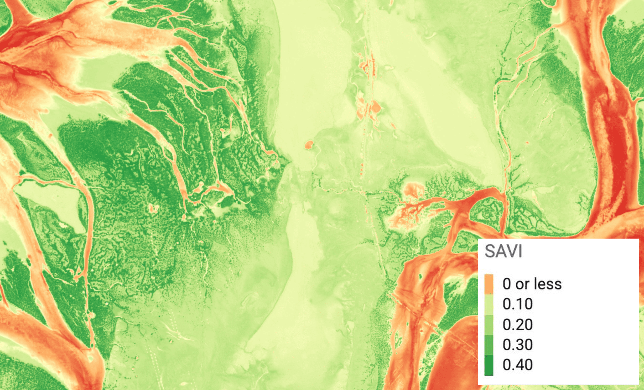
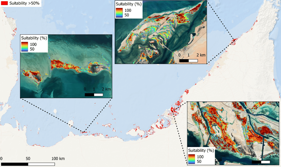
Plan
AI-led site suitability scoring: restoration zone mapping integrating hydrology, salinity gradients, sediment dynamics, and species-habitat fit. Interventions tested against multiple failure conditions.
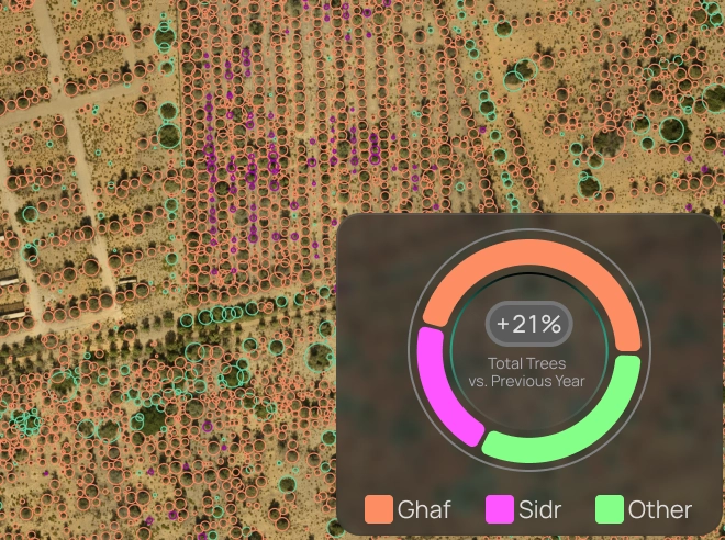
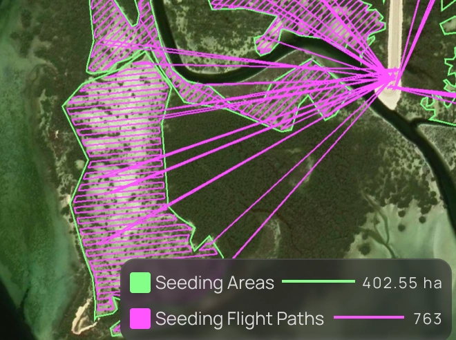
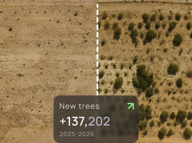
Restore
Autonomous seeding mission planning and execution: AI-optimized UAV flight paths, precision dispersal by site zone. Seed and sapling detection. Ground-truth integration for emergence confirmation.
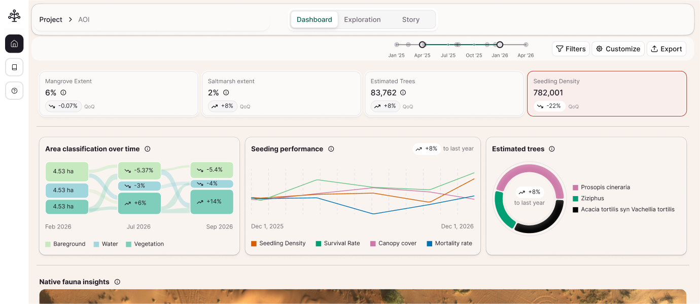
Monitor
Continuous satellite and drone-based growth tracking: risk alerts and health change detection in near real-time. Stress signals detected before they become visible to the human eye.
Verify
Data-lineage-backed outcome verification: carbon sequestration estimates, biodiversity recovery metrics, audit-ready reporting for carbon markets and compliance.
Ether
Nabat's self-supervised geospatial AI foundation model — trained on petabytes of coastal and arid habitat data at mm-level resolution, across millions of hectares.
It drives every analysis in NabatOS: from land cover classification and site suitability scoring to biomass estimation, carbon sequestration modeling, and real-time health change detection. Purpose-built for the ecosystems where no off-the-shelf model works.
Millions ha
coverage
Petabytes
training data
mm-level
resolution
Field-validated
by in-house ecologists
Task-specific AI models
See NabatOS in action
Nabat Restoration
Nabat expert services deliver real-world outcomes – combining science, technology, and community engagement.
Nature program
Design · Planning · Delivery · Monitoring
High-precision data capture
mm resolution · Aerial & marine · Optical, LiDar, SAR
Autonomous aerial seeding
large scale · Science-led
Ecology consulting
Methodology · Ground truthing
Community engagement
Knowledge transfer · Capacity building
Ready to design your program?
Solutions
Our solutions support the full journey of government environmental agencies, corporate ESGs, project developers, and nature investors. From accurate data to scalable action, to verified outcomes.
Ecosystem Intelligence
Ether, our proprietary geospatial AI model, delivers mm-resolution habitat mapping — species ID, canopy structure, biomass, health change detection — across millions of hectares. Purpose-built for coastal and arid ecosystems.
Ecosystem Restoration
AI-driven site selection, autonomous drone seeding, and continuous growth monitoring — validated by in-house ecologists in the field.
Digital MRV
Digital monitoring, reporting, and verification (DMRV) - continuous, spatially comprehensive, AI-powered verification against consistent ecological baselines.
Case studies
Government Agency

Technology-led mangrove restoration & monitoring
Challenge
Deliver large-scale coastal restoration with measurable, verifiable ecological impact
Solution
AI-powered site suitability scoring, autonomous UAV seeding missions, AI-led sapling health monitoring backed by ground truthing
20,000 hectares to be restored. Growth and health monitored continuously across the full program area
Forest Management Operator
Large-scale forest survey & monitoring
Challenge
Manual forest monitoring is costly, low-resolution, and slow to act on
Solution
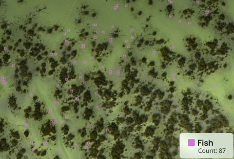
High-resolution imagery and proprietary AI models for automated forest monitoring and biodiversity assessment
Delivered automated species detection & count, and data-driven ecosystem management decisions with cost saving
Government & National Regulator
Terrestrial & marine habitat classification & health assessment
Challenge
Accurately map and assess terrestrial and marine habitats at national scale
Solution
AI-driven habitat classification and ecosystem health assessment across land and marine habitats
Enabled national conservation planning, across 43 terrestrial and 14 marine habitats
Our team
Built at the intersection of AI, ecology, and large-scale field delivery.

Reda Nidhakou
Chief Executive Officer

Mehdi Ajana
Head of Strategy

Taha Ghaznavi
Chief Product Officer

Georges Ibrahim
Vice President of Operations

Nada El Shanawany
Operations Manager

Stevie-Joe Van De Peer
Flight Operations Manager

Amine Marrakchi
STRATEGY PROJECT MANAGER

Roberto Queiroz
Business Development Manager
Insights & research
Drawing the Boundaries: Understanding Mangrove Extent in a Changing Landscape
When we talk about mangrove restoration or conservation, one of the first questions we ask is deceptively simple: Where are the mangroves?At first glance, the answer seems obvious. You can see cluster...
Measuring Health: How Remote Sensing and Field Verification Work Together
In environmental work, some of the most important changes are also the hardest to see. You can stand in a mangrove forest and sense that something isn...
Restoration Fails Quietly. Here's Why.
Restoration Fails Quietly. Here's Why.The dominant narrative around ecosystem restoration is one of ambition - trees planted, hectares restored, globa...
