%20--%3e%3cg%3e%3cg%20id='Layer_1'%3e%3cg%3e%3cg%3e%3cg%3e%3cg%3e%3cpath%20class='cls-1'%20d='M54.7,12.3c-1.4-1-3.3-1.6-5.5-1.6s-4.1.5-5.5,1.6c-1.7,1.2-2.5,2.9-2.5,5v11.8h5v-11.8c0-.4.1-.7.5-.9.6-.4,1.4-.6,2.6-.6s2,.2,2.6.6c.3.2.4.5.4.9v9.8c0,.5.2,1,.6,1.4.4.4.8.6,1.4.6h3v-11.8c0-2.1-.8-3.7-2.5-5Z'/%3e%3cpath%20class='cls-1'%20d='M75.4,11.1c-1,0-1.9.4-2.5,1.1-1.5-1.1-3.4-1.6-5.5-1.5s-4.4,1.1-6,2.7-2.7,4-2.7,6.5,1,4.9,2.7,6.7,4,2.7,6.6,2.7,3.4-.5,4.8-1.5c.6.7,1.4,1.1,2.5,1.1h1.7V11.1h-1.7ZM71.2,23.2c-.9.9-1.9,1.3-3.2,1.3s-2.3-.5-3.1-1.3-1.2-1.8-1.2-3,.4-2.3,1.2-3.1,1.9-1.3,3.1-1.3,2.2.4,3.1,1.3c.9.9,1.3,1.9,1.3,3.1s-.4,2.2-1.3,3.1h0Z'/%3e%3cpath%20class='cls-1'%20d='M89.5,10.7c-1.5,0-2.8.3-4,1v-6.8h-5v24.1h1.7c1,0,1.9-.4,2.5-1.1,1.5,1.1,3.2,1.6,5.2,1.5s4.7-1.1,6.3-2.8,2.7-4,2.7-6.5-.9-4.8-2.7-6.6c-1.8-1.8-4-2.7-6.6-2.7ZM92.6,23.2c-.9.9-1.9,1.3-3.1,1.3s-2.3-.5-3.1-1.3-1.3-1.9-1.3-3.1.5-2.3,1.3-3.1,1.9-1.3,3.1-1.3,2.3.5,3.1,1.3,1.3,1.9,1.3,3.1-.5,2.3-1.3,3.1Z'/%3e%3cpath%20class='cls-1'%20d='M116.3,11.1c-1,0-1.9.4-2.5,1.1-1.5-1.1-3.4-1.6-5.5-1.5s-4.4,1.1-6,2.7-2.7,4-2.7,6.5,1,4.9,2.7,6.7,4,2.7,6.6,2.7,3.4-.5,4.8-1.5c.6.7,1.4,1.1,2.5,1.1h1.7V11.1h-1.7ZM112.1,23.2c-.9.9-1.9,1.3-3.2,1.3s-2.3-.5-3.1-1.3-1.2-1.8-1.2-3,.4-2.3,1.2-3.1,1.9-1.3,3.1-1.3,2.2.4,3.1,1.3c.9.9,1.3,1.9,1.3,3.1s-.4,2.2-1.3,3.1h0Z'/%3e%3cpath%20class='cls-1'%20d='M157.2,11.1c-1,0-1.9.4-2.5,1.1-1.5-1.1-3.4-1.6-5.5-1.5s-4.4,1.1-6,2.7c-1.8,1.8-2.7,4-2.7,6.5s1,4.9,2.7,6.7,4,2.7,6.6,2.7,3.4-.5,4.8-1.5c.6.7,1.4,1.1,2.5,1.1h1.7V11.1h-1.7ZM153,23.2c-.9.9-1.9,1.3-3.2,1.3s-2.3-.5-3.1-1.3-1.2-1.8-1.2-3,.4-2.3,1.2-3.1,1.9-1.3,3.1-1.3,2.2.4,3.1,1.3c.9.9,1.3,1.9,1.3,3.1s-.4,2.2-1.3,3.1h0Z'/%3e%3cpath%20class='cls-1'%20d='M164.6,10.6c.8,0,1.5-.3,2.1-.9.6-.6.9-1.3.9-2.1s-.3-1.5-.9-2.1c-.6-.6-1.3-.9-2.1-.9s-1.5.3-2.1.9c-.6.6-.9,1.3-.9,2.1s.3,1.5.9,2.1c.6.6,1.3.9,2.1.9Z'/%3e%3c/g%3e%3cpath%20class='cls-1'%20d='M130.2,24c0,0-.2,0-.2.1-.3.2-1.8.3-2.3.3s-1.1-.1-1.4-.4c-.2-.2-.3-.6-.3-1.2v-6.8h2.4c.5,0,1-.2,1.4-.6.4-.4.6-.8.6-1.4v-3h-4.3v-1.6c0-.5-.1-1-.4-1.4-.7-1.1-1.7-1.6-2.8-1.6h-1.7v16.4c0,1.9.6,3.5,1.9,4.7,1.2,1.2,2.8,1.8,4.8,1.8s1.8,0,2.6-.2v-5.3Z'/%3e%3c/g%3e%3crect%20class='cls-1'%20x='162'%20y='11.6'%20width='5'%20height='17.6'/%3e%3cpath%20class='cls-1'%20d='M139.6,26.1c0,1.8-1.5,3.3-3.3,3.3s-2.6-.2-2.8-.2c0,0-.5-2.2-.5-3.1,0-1.8,1.5-3.3,3.3-3.3s2.8.1,3,.4c.2.4.4,2,.4,3Z'/%3e%3c/g%3e%3cpath%20class='cls-1'%20d='M29.3,17.5c-1.9,0-3.5,1.3-3.9,3h-.3c-2.8,0-5.3,1.2-7,3.1v-4.9c0-3.3.5-4.5,3.2-4.6.5,1.6,2,2.7,3.8,2.7s4-1.8,4-4-1.8-4-4-4-3.3,1.2-3.8,2.9c-1.3,0-2.3.3-3.1.7v-4.6c1.6-.5,2.7-2,2.7-3.8S19,.2,16.8.2s-4,1.8-4,4,1.2,3.3,2.9,3.8v4.6c-.8-.5-1.9-.7-3.3-.8-.5-1.7-2-2.9-3.8-2.9s-4,1.8-4,4,1.8,4,4,4,3.2-1.1,3.8-2.7c0,0,0,0,0,0,2.8,0,3.3,1.1,3.3,4.6v4.9c-1.7-1.9-4.2-3.1-7-3.1h-.7c-.4-1.7-2-3-3.9-3S0,19.3,0,21.5s1.8,4,4,4,3.1-1,3.7-2.5h.9c3.9,0,7,3.1,7,7v1.6h-4.2c-.7,0-1.2.5-1.2,1.2s.5,1.2,1.2,1.2h10.9c.7,0,1.2-.5,1.2-1.2s-.5-1.2-1.2-1.2h-4.2v-1.6c0-3.9,3.2-7,7-7h.5c.6,1.5,2,2.5,3.7,2.5s4-1.8,4-4-1.8-4-4-4ZM25,11.4c.9,0,1.6.7,1.6,1.6s-.7,1.6-1.6,1.6-1.6-.7-1.6-1.6.7-1.6,1.6-1.6ZM8.6,14.5c-.9,0-1.6-.7-1.6-1.6s.7-1.6,1.6-1.6,1.6.7,1.6,1.6-.7,1.6-1.6,1.6ZM4.1,23.1c-.9,0-1.6-.7-1.6-1.6s.7-1.6,1.6-1.6,1.6.7,1.6,1.6-.7,1.6-1.6,1.6ZM16.8,5.7c-.9,0-1.6-.7-1.6-1.6s.7-1.6,1.6-1.6,1.6.7,1.6,1.6-.7,1.6-1.6,1.6ZM29.3,23.1s0,0,0,0c0,0,0,0,0,0,0,0-.1,0-.2,0,0,0,0,0,0,0-.8-.1-1.3-.8-1.3-1.5s.6-1.5,1.4-1.6c0,0,0,0,0,0,0,0,0,0,0,0s0,0,0,0c0,0,0,0,0,0,.9,0,1.6.7,1.6,1.6s-.7,1.6-1.6,1.6Z'/%3e%3c/g%3e%3c/g%3e%3c/g%3e%3c/svg%3e)

In environmental work, some of the most important changes are also the hardest to see. You can stand in a mangrove forest and sense that something isn’t quite right - perhaps the canopy feels thinner, or the tones of green slightly muted - but understanding what is happening beneath that impression requires something more precise.
This is where remote sensing becomes essential. It gives us a way to move beyond observation and into understanding. At Nabat, much of our work sits in that space: using data not just to measure ecosystems, but to make visible the changes that would otherwise remain subtle, gradual, and easy to miss.
The stakes for doing this well are significant. Mangroves are among the most valuable ecosystems on the planet, storing vast amounts of carbon, protecting coastlines, and supporting rich biodiversity. And yet, they are under increasing pressure. What makes this particularly challenging is that decline is not always dramatic. It often begins quietly, in ways that are difficult to detect until the damage is already underway.
A large part of how we monitor these systems relies on vegetation indices such as NDVI (Normalized Difference Vegetation Index), SAVI (Soil-Adjusted Vegetation Index), and EVI (Enhanced Vegetation Index). They are often described in technical terms, but at their core, they are answering a simple question: how healthy is the vegetation we are looking at?
They do this by analyzing how plants interact with light. Healthy vegetation absorbs most visible light - particularly the red wavelengths used in photosynthesis - while reflecting near-infrared light. By measuring that contrast, sensors mounted on satellites and drones can generate a reliable signal of plant vitality across entire landscapes.
NDVI is the most widely used of these indices, providing a broad indication of vegetation “greenness” and acting as a useful baseline for tracking change over time. SAVI builds on this by adjusting for the influence of exposed soil, which is particularly important in environments where vegetation is sparse or patchy. EVI takes the analysis a step further again, improving sensitivity in denser vegetation and reducing atmospheric effects, making it better suited for detecting more subtle changes in canopy structure and health.
Individually, each index tells part of the story. Together, they begin to reveal patterns that would be difficult to capture in any other way.
At Nabat, translating that theory into something meaningful requires a carefully structured workflow. We capture high-resolution multispectral imagery using UAV-mounted sensors, calibrated before each flight to ensure consistency and accuracy regardless of changing light conditions. What starts as raw spectral data is then processed into layered, spatially accurate imagery that allows us to map vegetation health in detail.
What stands out in practice isn’t the process itself, but what the results begin to reveal. When the data is visualized, subtle variations in vegetation start to take shape as patterns. Areas of strong growth become clearer, while zones under stress emerge in ways that would be difficult-if not impossible-to detect from the ground alone. It’s often in that moment that the technology becomes meaningful-not as a system, but as a way of revealing patterns that would otherwise remain hidden. That same analysis is extended to the landscape scale using satellite data, allowing us to track change consistently across far larger areas. The combination of drone-level precision and satellite-level coverage creates something much more powerful than either could provide on its own.
And yet, one of the most important things to understand about this kind of data is that it does not tell the whole story.
It can show us where change is happening, and how it is evolving over time, but it rarely tells us why. A drop in vegetation index values might indicate stress, but without context it could just as easily be driven by natural seasonal variation, shifting salinity levels, hydrological changes, or human activity.
This is where field verification becomes essential.
Spending time on the ground - assessing soil conditions, observing species composition, tracking sapling survival - brings a level of clarity that remote sensing alone cannot provide. It allows us to test what the data is suggesting, to refine our understanding, and to build confidence in the conclusions we draw.
In many ways, this is where hard work happens. Remote sensing gives us scale and consistency; field data gives us truth. When the two are used together, the result is not just better data, but better judgment.
Remote sensing gives us scale and consistency; field data gives us truth.
What has become increasingly clear is that this kind of monitoring is no longer just about improving efficiency or insight. In regions like the Gulf, it is becoming something more fundamental.
Mangrove ecosystems here exist under a unique set of pressures. Extreme heat, high salinity, and limited freshwater inputs already create demanding conditions. Alongside that, rapid coastal development and broader regional instability add layers of uncertainty that are harder to predict and track. It is exactly this combination of stressors that shapes how Nabat approaches monitoring across the mangrove program - tracking not just change, but the compounding conditions that drive it. [
In this context, change does not always announce itself. It builds gradually, often beneath the threshold of immediate visibility. And that is exactly why continuous monitoring matters.
What makes tools like NDVI, SAVI, and EVI so powerful is not just what they show, but when they show it. Long before visible degradation appears on the ground, these indices begin to shift. A slight weakening in vegetation health. A subtle thinning of canopy. Signals that, taken on their own, might seem insignificant, but together point to a system under stress.
Those early signals create something incredibly valuable: time.
- Time to investigate what is happening.
- Time to validate with field observations.
- Time to respond before decline becomes irreversible.
Ultimately, these tools are not solutions in themselves. They are part of a wider system - one that connects observation, verification, and action.
What they offer is clarity, and with that clarity comes responsibility.
The ability to monitor ecosystems at scale means we are better equipped than ever to understand how they are changing. But it also means that the decisions that follow carry more weight. In places like the Gulf, where mangroves underpin coastal resilience, biodiversity, and long-term environmental stability, that responsibility is immediate and ongoing.
For me, this is what the work ultimately comes back to. Not just measuring ecosystems, but understanding them well enough to act at the right moment, in the right way.
Because in a world where both environmental and external pressures are only becoming more complex, the difference between seeing change and missing it is the difference between intervention and loss.
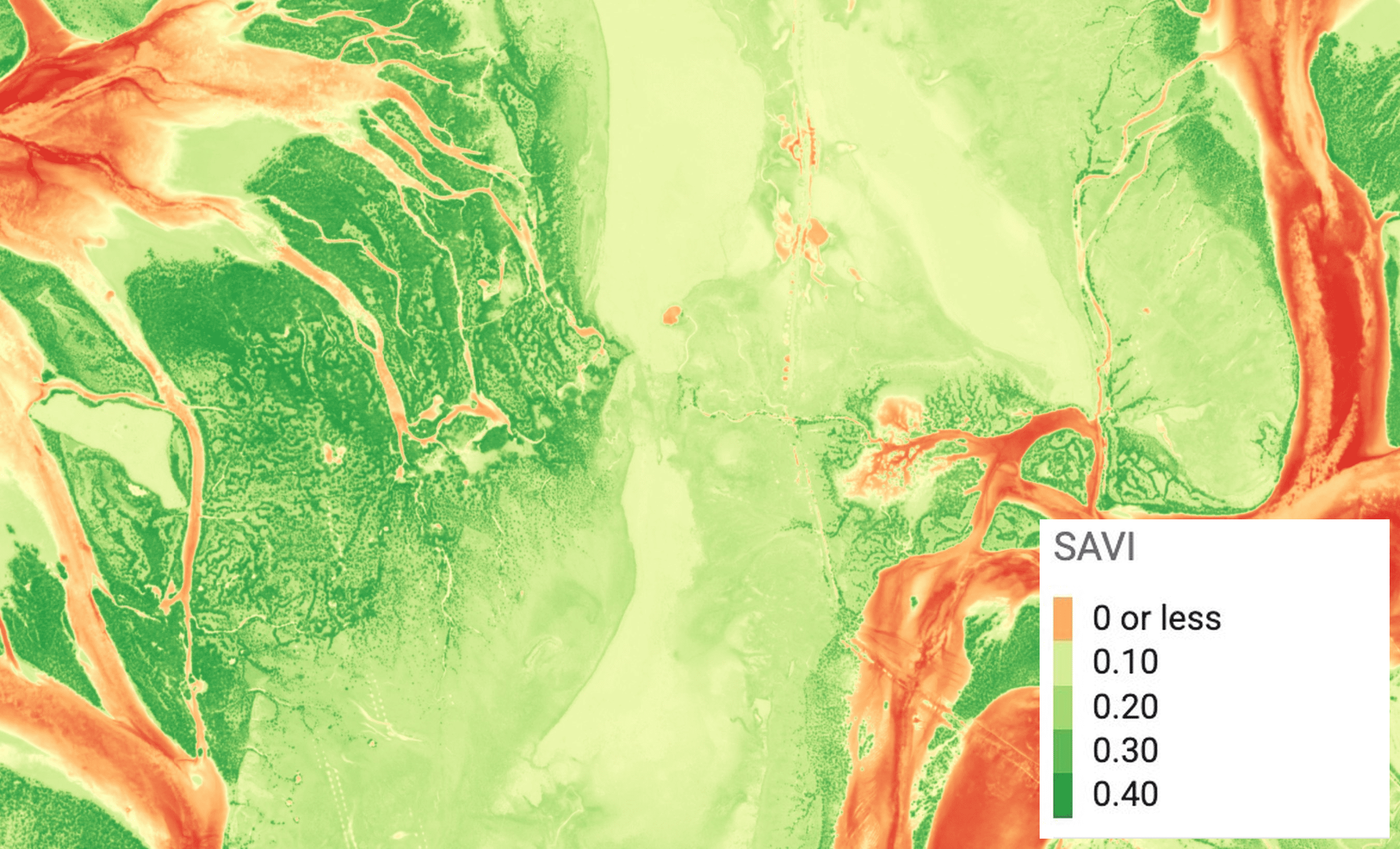
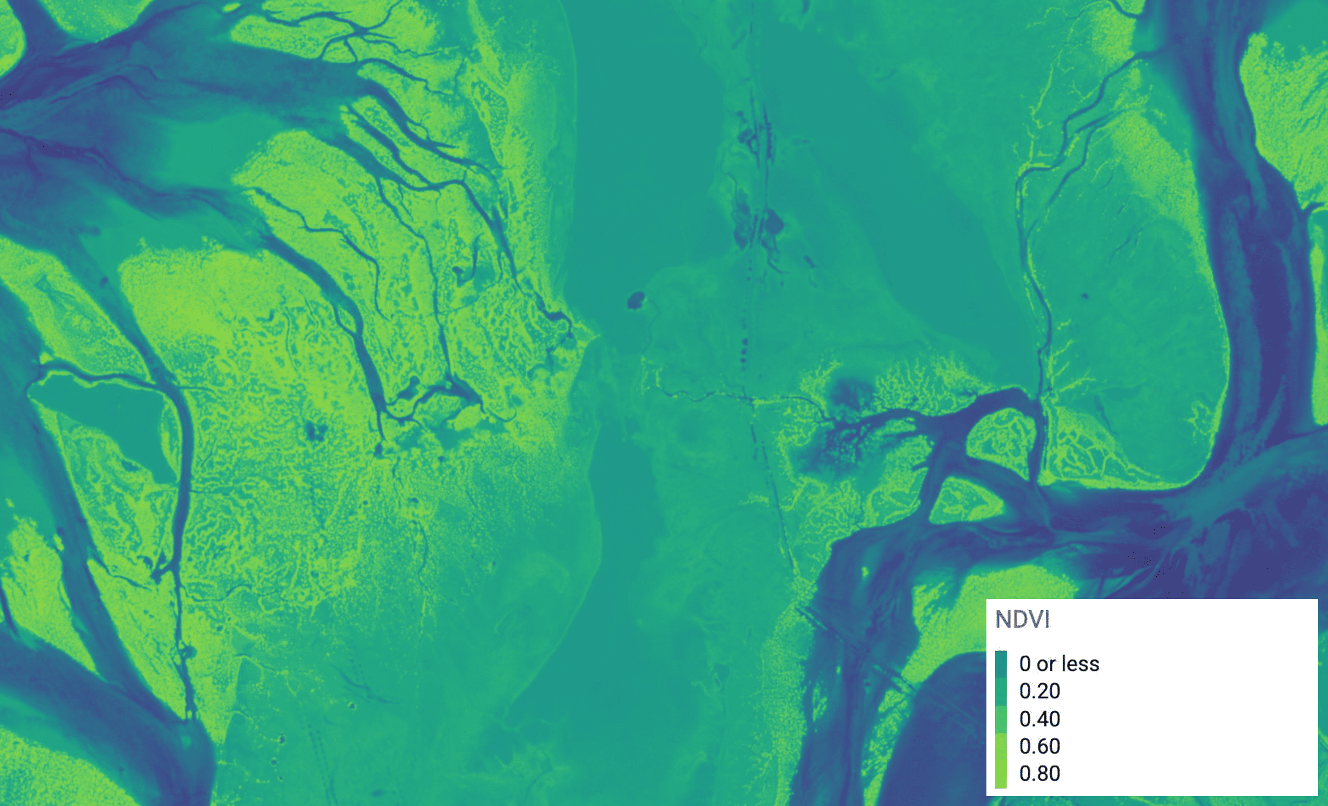
SAVI and NDVI visualization of the same area