By Vanessa Randon, Ecology Tech Manager, Nabat
23 September 2026
Over several decades, millions of trees have been planted across the UAE as part of ambitious afforestation and land management programs. The challenge now is not simply how to establish forests in one of the world’s most arid environments, but how to understand what is happening within them - potentially tree by tree.
For the organizations responsible for these landscapes, that shift creates a new forest monitoring challenge: understanding the condition and trajectory of individual trees at scale.
The reality is that maintaining forests in a hyper-arid environment is not simply a matter of planting trees and walking away. Water sits at the centre of the challenge. Historically, many afforestation projects relied heavily on groundwater resources, but growing pressure on those reserves has prompted a shift toward treated sewage effluent (TSE), recycled water, and increasingly sophisticated irrigation strategies. As irrigation systems become more intelligent, the forests they support increasingly need to become more measurable.
Landscape-level assessments remain essential, but they cannot answer every management question. Which species are present? Which trees are thriving, and which are under stress? How is forest condition changing through time? Where should resources be focused, and how can management decisions be supported with confidence?
Every Tree Tells a Different Story
Recently, I had the opportunity to spend time in one of these forests, and before we had even unpacked the drones or discussed the survey plan, the forest manager offered one piece of advice: “Make sure you’re wearing boots. We occasionally encounter snakes here,” he explained. It wasn’t quite the welcome I’d been expecting, but it was a timely reminder that although these forests are carefully managed, they remain living ecosystems. They’re dynamic, unpredictable, and wonderfully complex. That complexity is exactly what makes understanding them so interesting.
Answering these questions across large forest estates requires significant field effort. Ecologists and forestry teams visit sites, identify species, assess condition, and compile a forest inventory through manual surveys. Those methods remain essential, but as forest estates expand, relying exclusively on field surveys becomes increasingly difficult. The challenge is how to extend the ecological understanding consistently and repeatedly across the scale required for modern forest management.
At Nabat, we approach this challenge by looking at the forest not only as a landscape, but as a population of individual ecological assets.
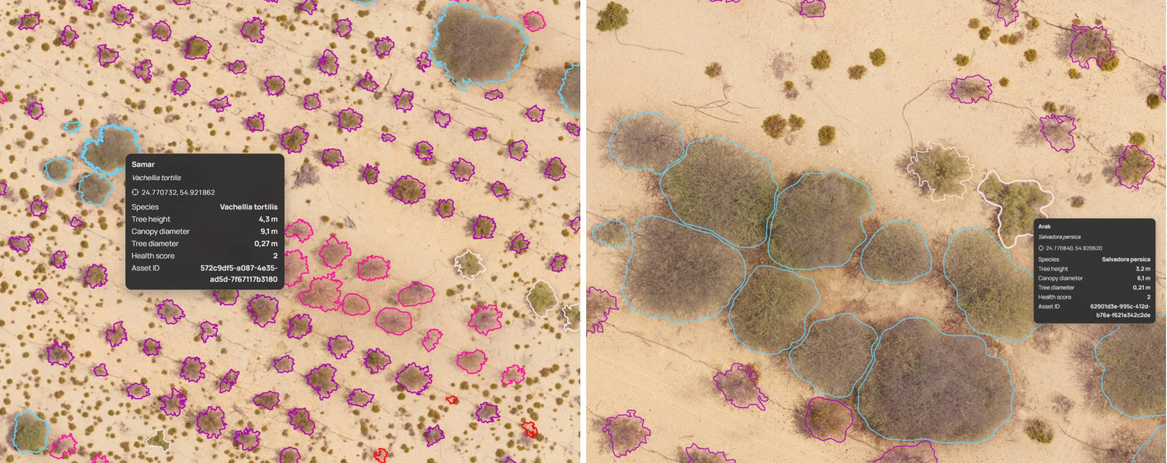
Using a combination of high-resolution drone imagery, ecological field validation, AI-assisted image analysis, and NabatOS, we have been exploring digital forest inventories built on individual tree detection, capable of identifying and characterizing individual trees. Instead of producing a simple map, the result is a living inventory where each tree can be associated with information such as genus, canopy height, crown diameter, health condition, and georeferenced imagery. The result is not simply a more detailed map, but a living digital inventory that can support a richer understanding of the landscape over time.
Images 1 & 2: From landscape to individual assets: each detected tree is identified, measured, and recorded within a digital inventory, supporting long-term forest monitoring at the level of individual trees rather than at the forest scale alone.
Seeing a Tree is Not the Same as Understanding It
Of course, forests rarely behave as neatly as our data models would like them to. Nature has never been particularly interested in fitting inside clean datasets. Canopies overlap. Different species can occupy the same canopy footprint. Trees compete for light, grow into one another, and create structures that are often far more complicated than they appear from above. These aren’t anomalies; they’re ecological realities, and any useful inventory system has to embrace that complexity rather than simplify it away.
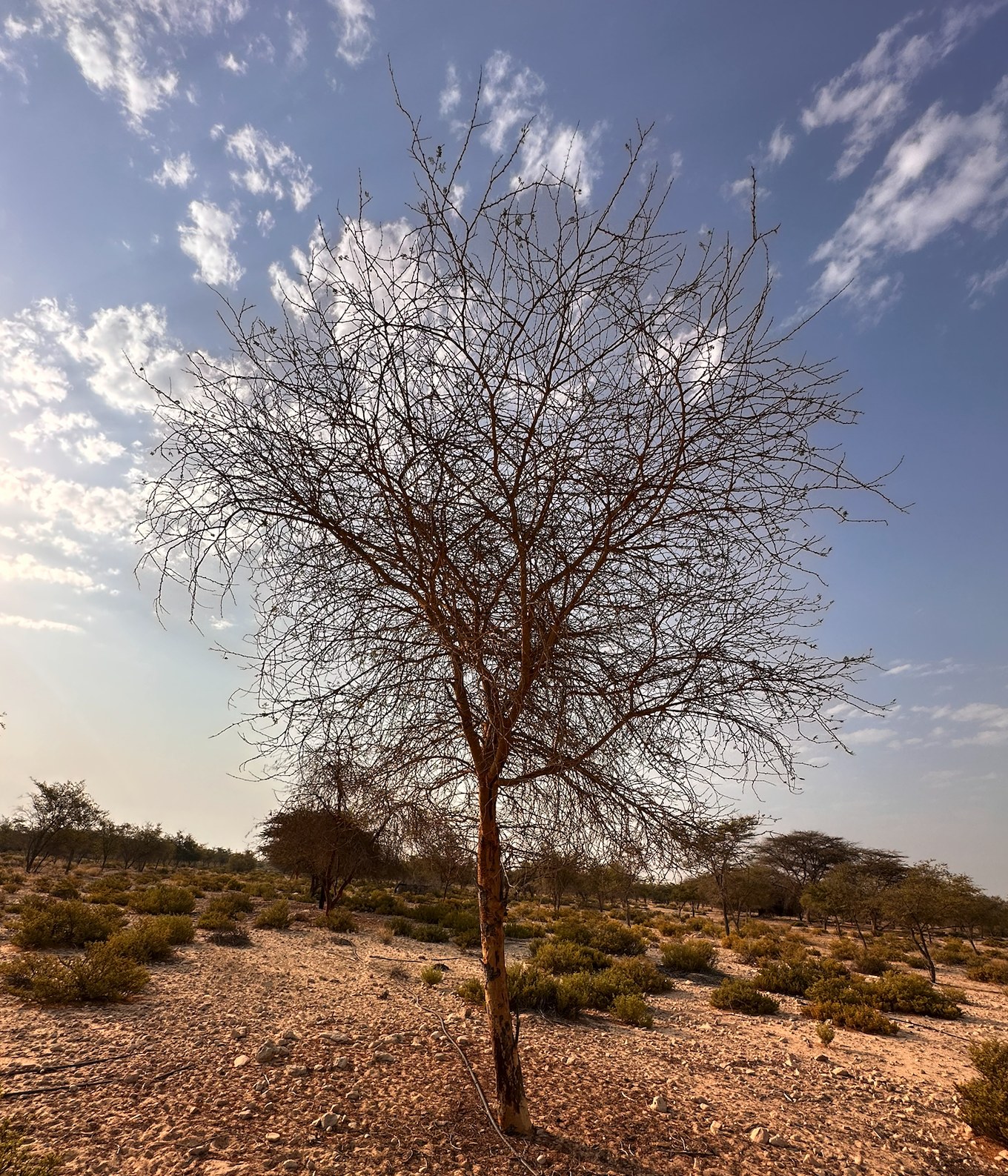
One moment from the field has stayed with me. We were discussing tree health monitoring when one expert explained that some Vachellia species, which looked almost lifeless from above, were actually entering their flowering season. Rather than investing energy into producing a dense green canopy, the trees had redirected those resources toward reproduction, leaving their crowns looking surprisingly sparse. If you’re relying solely on aerial imagery, it’s easy to assume those trees are unhealthy.
Then he shared something that I found fascinating. When the team wants to understand whether a Vachellia is truly dead, they don’t start by looking at the canopy - they look at the trunk. The canopy might simply reflect the season, but the trunk tells a very different story.
Image: Vachellia tortilis (formerly Acacia tortilis) standing resilient in the UAE desert. A keystone species of arid ecosystems, it provides shade, habitat, and resources for a wide range of wildlife. Although its sparse canopy may appear to indicate stress, the tree is highly adapted to desert conditions and can shed much of its foliage during flowering and dry periods, reducing water loss while conserving resources for reproduction and survival.
It was one of those moments that perfectly captured why ecology and technology must work together. Remote sensing allows us to observe forests at remarkable scales, but ecological expertise provides the context that transforms observations into understanding. Effective tree health monitoring depends on both.
This idea builds directly on themes explored throughout our previous blogs. Whether discussing vegetation health indices such as NDVI and SAVI, habitat mapping, or restoration planning, the same principle applies environmental data becomes most valuable when it is interpreted within its ecological context.
Building a History, Not Just an Inventory
The real value emerges when forest inventories are repeated over months and years and used to inform management decisions. A single inventory provides a snapshot, but repeated inventories reveal how a forest is changing. Growth can be measured, areas of decline identified earlier, and the effect of management interventions, evaluated. This kind of continuous forest monitoring can help teams decide where to inspect, where to intervene and where resources are best directed. What was once a static picture becomes a living timeline, allowing managers to understand not only what exists today, but how the landscape is evolving.
This becomes increasingly important as organizations move beyond reporting and toward active stewardship. Forests are not simply collections of trees; they are long-term environmental investments that require continual care. Irrigation networks require maintenance. Water use must be optimized. Different species respond differently to environmental conditions. Tree-by-tree information allows these decisions to become more targeted, showing where attention is genuinely needed rather than treating an entire forest estate as one uniform block.
Importantly, a digital forest inventory does not replace ecological expertise - it amplifies it. It extends observations that might once have been limited to a small number of field plots across entire landscapes while maintaining the ecological understanding needed to interpret them correctly.
From Observation to Action
Perhaps that’s the biggest shift of all. A forest does not stop being a forest. It simply becomes understandable in a different way. Rather than relying solely on broad landscape assessments, individual tree detection allows managers to begin exploring the condition, structure and history of individual trees while still understanding how those trees contribute to the health of the wider ecosystem.
The opportunity is not simply to collect more environmental data. It is to turn repeated observations into a record of change – one that helps managers detect change earlier, target interventions more precisely and understand whether those interventions are working.
Sometimes, looking after an entire forest begins with understanding a single tree.
Vanessa Randon, Ecology Tech Manager
My work focuses on bridging ecology and technology to support landscape restoration at scale. At Nabat, I develop ecological data systems, standards, and annotation frameworks that power our AI and machine learning models. Working closely with ecologists, engineers, and product teams, I translate complex ecological knowledge into practical, data-driven solutions for monitoring and restoring ecosystems. I am passionate about using technology to deliver measurable environmental outcomes and accelerate ecosystem recovery.
%20--%3e%3cg%3e%3cg%20id='Layer_1'%3e%3cg%3e%3cg%3e%3cg%3e%3cg%3e%3cpath%20class='cls-1'%20d='M54.7,12.3c-1.4-1-3.3-1.6-5.5-1.6s-4.1.5-5.5,1.6c-1.7,1.2-2.5,2.9-2.5,5v11.8h5v-11.8c0-.4.1-.7.5-.9.6-.4,1.4-.6,2.6-.6s2,.2,2.6.6c.3.2.4.5.4.9v9.8c0,.5.2,1,.6,1.4.4.4.8.6,1.4.6h3v-11.8c0-2.1-.8-3.7-2.5-5Z'/%3e%3cpath%20class='cls-1'%20d='M75.4,11.1c-1,0-1.9.4-2.5,1.1-1.5-1.1-3.4-1.6-5.5-1.5s-4.4,1.1-6,2.7-2.7,4-2.7,6.5,1,4.9,2.7,6.7,4,2.7,6.6,2.7,3.4-.5,4.8-1.5c.6.7,1.4,1.1,2.5,1.1h1.7V11.1h-1.7ZM71.2,23.2c-.9.9-1.9,1.3-3.2,1.3s-2.3-.5-3.1-1.3-1.2-1.8-1.2-3,.4-2.3,1.2-3.1,1.9-1.3,3.1-1.3,2.2.4,3.1,1.3c.9.9,1.3,1.9,1.3,3.1s-.4,2.2-1.3,3.1h0Z'/%3e%3cpath%20class='cls-1'%20d='M89.5,10.7c-1.5,0-2.8.3-4,1v-6.8h-5v24.1h1.7c1,0,1.9-.4,2.5-1.1,1.5,1.1,3.2,1.6,5.2,1.5s4.7-1.1,6.3-2.8,2.7-4,2.7-6.5-.9-4.8-2.7-6.6c-1.8-1.8-4-2.7-6.6-2.7ZM92.6,23.2c-.9.9-1.9,1.3-3.1,1.3s-2.3-.5-3.1-1.3-1.3-1.9-1.3-3.1.5-2.3,1.3-3.1,1.9-1.3,3.1-1.3,2.3.5,3.1,1.3,1.3,1.9,1.3,3.1-.5,2.3-1.3,3.1Z'/%3e%3cpath%20class='cls-1'%20d='M116.3,11.1c-1,0-1.9.4-2.5,1.1-1.5-1.1-3.4-1.6-5.5-1.5s-4.4,1.1-6,2.7-2.7,4-2.7,6.5,1,4.9,2.7,6.7,4,2.7,6.6,2.7,3.4-.5,4.8-1.5c.6.7,1.4,1.1,2.5,1.1h1.7V11.1h-1.7ZM112.1,23.2c-.9.9-1.9,1.3-3.2,1.3s-2.3-.5-3.1-1.3-1.2-1.8-1.2-3,.4-2.3,1.2-3.1,1.9-1.3,3.1-1.3,2.2.4,3.1,1.3c.9.9,1.3,1.9,1.3,3.1s-.4,2.2-1.3,3.1h0Z'/%3e%3cpath%20class='cls-1'%20d='M157.2,11.1c-1,0-1.9.4-2.5,1.1-1.5-1.1-3.4-1.6-5.5-1.5s-4.4,1.1-6,2.7c-1.8,1.8-2.7,4-2.7,6.5s1,4.9,2.7,6.7,4,2.7,6.6,2.7,3.4-.5,4.8-1.5c.6.7,1.4,1.1,2.5,1.1h1.7V11.1h-1.7ZM153,23.2c-.9.9-1.9,1.3-3.2,1.3s-2.3-.5-3.1-1.3-1.2-1.8-1.2-3,.4-2.3,1.2-3.1,1.9-1.3,3.1-1.3,2.2.4,3.1,1.3c.9.9,1.3,1.9,1.3,3.1s-.4,2.2-1.3,3.1h0Z'/%3e%3cpath%20class='cls-1'%20d='M164.6,10.6c.8,0,1.5-.3,2.1-.9.6-.6.9-1.3.9-2.1s-.3-1.5-.9-2.1c-.6-.6-1.3-.9-2.1-.9s-1.5.3-2.1.9c-.6.6-.9,1.3-.9,2.1s.3,1.5.9,2.1c.6.6,1.3.9,2.1.9Z'/%3e%3c/g%3e%3cpath%20class='cls-1'%20d='M130.2,24c0,0-.2,0-.2.1-.3.2-1.8.3-2.3.3s-1.1-.1-1.4-.4c-.2-.2-.3-.6-.3-1.2v-6.8h2.4c.5,0,1-.2,1.4-.6.4-.4.6-.8.6-1.4v-3h-4.3v-1.6c0-.5-.1-1-.4-1.4-.7-1.1-1.7-1.6-2.8-1.6h-1.7v16.4c0,1.9.6,3.5,1.9,4.7,1.2,1.2,2.8,1.8,4.8,1.8s1.8,0,2.6-.2v-5.3Z'/%3e%3c/g%3e%3crect%20class='cls-1'%20x='162'%20y='11.6'%20width='5'%20height='17.6'/%3e%3cpath%20class='cls-1'%20d='M139.6,26.1c0,1.8-1.5,3.3-3.3,3.3s-2.6-.2-2.8-.2c0,0-.5-2.2-.5-3.1,0-1.8,1.5-3.3,3.3-3.3s2.8.1,3,.4c.2.4.4,2,.4,3Z'/%3e%3c/g%3e%3cpath%20class='cls-1'%20d='M29.3,17.5c-1.9,0-3.5,1.3-3.9,3h-.3c-2.8,0-5.3,1.2-7,3.1v-4.9c0-3.3.5-4.5,3.2-4.6.5,1.6,2,2.7,3.8,2.7s4-1.8,4-4-1.8-4-4-4-3.3,1.2-3.8,2.9c-1.3,0-2.3.3-3.1.7v-4.6c1.6-.5,2.7-2,2.7-3.8S19,.2,16.8.2s-4,1.8-4,4,1.2,3.3,2.9,3.8v4.6c-.8-.5-1.9-.7-3.3-.8-.5-1.7-2-2.9-3.8-2.9s-4,1.8-4,4,1.8,4,4,4,3.2-1.1,3.8-2.7c0,0,0,0,0,0,2.8,0,3.3,1.1,3.3,4.6v4.9c-1.7-1.9-4.2-3.1-7-3.1h-.7c-.4-1.7-2-3-3.9-3S0,19.3,0,21.5s1.8,4,4,4,3.1-1,3.7-2.5h.9c3.9,0,7,3.1,7,7v1.6h-4.2c-.7,0-1.2.5-1.2,1.2s.5,1.2,1.2,1.2h10.9c.7,0,1.2-.5,1.2-1.2s-.5-1.2-1.2-1.2h-4.2v-1.6c0-3.9,3.2-7,7-7h.5c.6,1.5,2,2.5,3.7,2.5s4-1.8,4-4-1.8-4-4-4ZM25,11.4c.9,0,1.6.7,1.6,1.6s-.7,1.6-1.6,1.6-1.6-.7-1.6-1.6.7-1.6,1.6-1.6ZM8.6,14.5c-.9,0-1.6-.7-1.6-1.6s.7-1.6,1.6-1.6,1.6.7,1.6,1.6-.7,1.6-1.6,1.6ZM4.1,23.1c-.9,0-1.6-.7-1.6-1.6s.7-1.6,1.6-1.6,1.6.7,1.6,1.6-.7,1.6-1.6,1.6ZM16.8,5.7c-.9,0-1.6-.7-1.6-1.6s.7-1.6,1.6-1.6,1.6.7,1.6,1.6-.7,1.6-1.6,1.6ZM29.3,23.1s0,0,0,0c0,0,0,0,0,0,0,0-.1,0-.2,0,0,0,0,0,0,0-.8-.1-1.3-.8-1.3-1.5s.6-1.5,1.4-1.6c0,0,0,0,0,0,0,0,0,0,0,0s0,0,0,0c0,0,0,0,0,0,.9,0,1.6.7,1.6,1.6s-.7,1.6-1.6,1.6Z'/%3e%3c/g%3e%3c/g%3e%3c/g%3e%3c/svg%3e)