%20--%3e%3cg%3e%3cg%20id='Layer_1'%3e%3cg%3e%3cg%3e%3cg%3e%3cg%3e%3cpath%20class='cls-1'%20d='M54.7,12.3c-1.4-1-3.3-1.6-5.5-1.6s-4.1.5-5.5,1.6c-1.7,1.2-2.5,2.9-2.5,5v11.8h5v-11.8c0-.4.1-.7.5-.9.6-.4,1.4-.6,2.6-.6s2,.2,2.6.6c.3.2.4.5.4.9v9.8c0,.5.2,1,.6,1.4.4.4.8.6,1.4.6h3v-11.8c0-2.1-.8-3.7-2.5-5Z'/%3e%3cpath%20class='cls-1'%20d='M75.4,11.1c-1,0-1.9.4-2.5,1.1-1.5-1.1-3.4-1.6-5.5-1.5s-4.4,1.1-6,2.7-2.7,4-2.7,6.5,1,4.9,2.7,6.7,4,2.7,6.6,2.7,3.4-.5,4.8-1.5c.6.7,1.4,1.1,2.5,1.1h1.7V11.1h-1.7ZM71.2,23.2c-.9.9-1.9,1.3-3.2,1.3s-2.3-.5-3.1-1.3-1.2-1.8-1.2-3,.4-2.3,1.2-3.1,1.9-1.3,3.1-1.3,2.2.4,3.1,1.3c.9.9,1.3,1.9,1.3,3.1s-.4,2.2-1.3,3.1h0Z'/%3e%3cpath%20class='cls-1'%20d='M89.5,10.7c-1.5,0-2.8.3-4,1v-6.8h-5v24.1h1.7c1,0,1.9-.4,2.5-1.1,1.5,1.1,3.2,1.6,5.2,1.5s4.7-1.1,6.3-2.8,2.7-4,2.7-6.5-.9-4.8-2.7-6.6c-1.8-1.8-4-2.7-6.6-2.7ZM92.6,23.2c-.9.9-1.9,1.3-3.1,1.3s-2.3-.5-3.1-1.3-1.3-1.9-1.3-3.1.5-2.3,1.3-3.1,1.9-1.3,3.1-1.3,2.3.5,3.1,1.3,1.3,1.9,1.3,3.1-.5,2.3-1.3,3.1Z'/%3e%3cpath%20class='cls-1'%20d='M116.3,11.1c-1,0-1.9.4-2.5,1.1-1.5-1.1-3.4-1.6-5.5-1.5s-4.4,1.1-6,2.7-2.7,4-2.7,6.5,1,4.9,2.7,6.7,4,2.7,6.6,2.7,3.4-.5,4.8-1.5c.6.7,1.4,1.1,2.5,1.1h1.7V11.1h-1.7ZM112.1,23.2c-.9.9-1.9,1.3-3.2,1.3s-2.3-.5-3.1-1.3-1.2-1.8-1.2-3,.4-2.3,1.2-3.1,1.9-1.3,3.1-1.3,2.2.4,3.1,1.3c.9.9,1.3,1.9,1.3,3.1s-.4,2.2-1.3,3.1h0Z'/%3e%3cpath%20class='cls-1'%20d='M157.2,11.1c-1,0-1.9.4-2.5,1.1-1.5-1.1-3.4-1.6-5.5-1.5s-4.4,1.1-6,2.7c-1.8,1.8-2.7,4-2.7,6.5s1,4.9,2.7,6.7,4,2.7,6.6,2.7,3.4-.5,4.8-1.5c.6.7,1.4,1.1,2.5,1.1h1.7V11.1h-1.7ZM153,23.2c-.9.9-1.9,1.3-3.2,1.3s-2.3-.5-3.1-1.3-1.2-1.8-1.2-3,.4-2.3,1.2-3.1,1.9-1.3,3.1-1.3,2.2.4,3.1,1.3c.9.9,1.3,1.9,1.3,3.1s-.4,2.2-1.3,3.1h0Z'/%3e%3cpath%20class='cls-1'%20d='M164.6,10.6c.8,0,1.5-.3,2.1-.9.6-.6.9-1.3.9-2.1s-.3-1.5-.9-2.1c-.6-.6-1.3-.9-2.1-.9s-1.5.3-2.1.9c-.6.6-.9,1.3-.9,2.1s.3,1.5.9,2.1c.6.6,1.3.9,2.1.9Z'/%3e%3c/g%3e%3cpath%20class='cls-1'%20d='M130.2,24c0,0-.2,0-.2.1-.3.2-1.8.3-2.3.3s-1.1-.1-1.4-.4c-.2-.2-.3-.6-.3-1.2v-6.8h2.4c.5,0,1-.2,1.4-.6.4-.4.6-.8.6-1.4v-3h-4.3v-1.6c0-.5-.1-1-.4-1.4-.7-1.1-1.7-1.6-2.8-1.6h-1.7v16.4c0,1.9.6,3.5,1.9,4.7,1.2,1.2,2.8,1.8,4.8,1.8s1.8,0,2.6-.2v-5.3Z'/%3e%3c/g%3e%3crect%20class='cls-1'%20x='162'%20y='11.6'%20width='5'%20height='17.6'/%3e%3cpath%20class='cls-1'%20d='M139.6,26.1c0,1.8-1.5,3.3-3.3,3.3s-2.6-.2-2.8-.2c0,0-.5-2.2-.5-3.1,0-1.8,1.5-3.3,3.3-3.3s2.8.1,3,.4c.2.4.4,2,.4,3Z'/%3e%3c/g%3e%3cpath%20class='cls-1'%20d='M29.3,17.5c-1.9,0-3.5,1.3-3.9,3h-.3c-2.8,0-5.3,1.2-7,3.1v-4.9c0-3.3.5-4.5,3.2-4.6.5,1.6,2,2.7,3.8,2.7s4-1.8,4-4-1.8-4-4-4-3.3,1.2-3.8,2.9c-1.3,0-2.3.3-3.1.7v-4.6c1.6-.5,2.7-2,2.7-3.8S19,.2,16.8.2s-4,1.8-4,4,1.2,3.3,2.9,3.8v4.6c-.8-.5-1.9-.7-3.3-.8-.5-1.7-2-2.9-3.8-2.9s-4,1.8-4,4,1.8,4,4,4,3.2-1.1,3.8-2.7c0,0,0,0,0,0,2.8,0,3.3,1.1,3.3,4.6v4.9c-1.7-1.9-4.2-3.1-7-3.1h-.7c-.4-1.7-2-3-3.9-3S0,19.3,0,21.5s1.8,4,4,4,3.1-1,3.7-2.5h.9c3.9,0,7,3.1,7,7v1.6h-4.2c-.7,0-1.2.5-1.2,1.2s.5,1.2,1.2,1.2h10.9c.7,0,1.2-.5,1.2-1.2s-.5-1.2-1.2-1.2h-4.2v-1.6c0-3.9,3.2-7,7-7h.5c.6,1.5,2,2.5,3.7,2.5s4-1.8,4-4-1.8-4-4-4ZM25,11.4c.9,0,1.6.7,1.6,1.6s-.7,1.6-1.6,1.6-1.6-.7-1.6-1.6.7-1.6,1.6-1.6ZM8.6,14.5c-.9,0-1.6-.7-1.6-1.6s.7-1.6,1.6-1.6,1.6.7,1.6,1.6-.7,1.6-1.6,1.6ZM4.1,23.1c-.9,0-1.6-.7-1.6-1.6s.7-1.6,1.6-1.6,1.6.7,1.6,1.6-.7,1.6-1.6,1.6ZM16.8,5.7c-.9,0-1.6-.7-1.6-1.6s.7-1.6,1.6-1.6,1.6.7,1.6,1.6-.7,1.6-1.6,1.6ZM29.3,23.1s0,0,0,0c0,0,0,0,0,0,0,0-.1,0-.2,0,0,0,0,0,0,0-.8-.1-1.3-.8-1.3-1.5s.6-1.5,1.4-1.6c0,0,0,0,0,0,0,0,0,0,0,0s0,0,0,0c0,0,0,0,0,0,.9,0,1.6.7,1.6,1.6s-.7,1.6-1.6,1.6Z'/%3e%3c/g%3e%3c/g%3e%3c/g%3e%3c/svg%3e)

In our previous blogs, we focused on coastal ecosystems - mapping mangrove extent, understanding transitional habitats, and using detailed classification to move from observation to action. We explored how ecosystem health can be monitored through vegetation indices, using remote sensing to detect changes that are not always visible on the ground. Together, these approaches helped build a clearer picture of how systems behave, and how they respond to intervention over time.
But beyond the coastline lies a very different kind of landscape - and one that, for a long time, has been overlooked.
Dryland environments often appear empty at first glance - vast expanses of exposed ground, scattered vegetation, long stretches where growth feels unlikely. That apparent simplicity, however, can be misleading. These systems are not inactive; they exist at the edge of what is possible, shaped by scarcity, variability, and finely balanced processes. There is something quietly remarkable about that: a plant that survives months without rainfall, drawing moisture through root systems that extend far deeper than the visible landscape suggests; a cluster of shrubs stabilizing a dune, slowing the movement of sand that would otherwise swallow whatever lies downwind. Small, tenacious acts of persistence that add up, over time, to something that matters.
Desertification remains one of the most significant - and often under reported - ecological challenges of our time. Land that once supported vegetation gradually loses its ability to retain moisture and sustain plant life, becoming harder to recover with each passing season. Globally, an estimated one billion hectares of dryland – 10 to 20 percent if the total – are already degraded. For regions like the Gulf, where environmental pressures are intensifying and restoration ambitions are growing, dryland ecosystems are no longer a peripheral concern - they are becoming a central front in ecological work.
At Nabat, these environments sit alongside coastal and marine systems as a core focus of our work - not as an afterthought, but as a frontier we are actively building toward.
As with mangroves, one of the first challenges is deceptively simple: what is the image showing us? Vegetation is sparse, often seasonal, and highly adapted to survive under extreme conditions. Small differences in land cover - bare ground versus degraded ground, viable vegetation versus stressed or dead cover - can determine whether an area has any potential to support life at all. These distinctions are not always obvious, and getting them wrong leads to interventions that do not hold.
At Nabat, we apply the same classification approach used in coastal systems to these environments, breaking the landscape into meaningful categories: bare ground, water, artificial surfaces, woody vegetation, herbaceous cover, and shrubs, alongside indicators of stress such as dead tree crowns and degraded vegetation.
These capabilities sit within NabatOS, our ecosystem intelligence platform - where land cover classification, ecosystem health monitoring, restoration planning, and long - term monitoring are brought together into a single workflow. The goal is not simply to generate maps, but to help organizations understand landscapes well enough to make better decisions within them. Whether the challenge is a coastal mangrove forest or a dryland restoration site hundreds of kilometres inland, the principle remains the same: better understanding leads to better action.
Each class tells a different part of the story. Woody vegetation in an otherwise bare landscape might indicate a moisture pathway running underground - a subtle signal worth following. Dead crowns in an area that was once stable suggest something has shifted: a drought event, overgrazing pressure, or a change in the water table. Herbaceous cover, even when sparse, can indicate that the soil below still holds enough to support recovery. None of these details are visible from a high - level view. All of them matter.
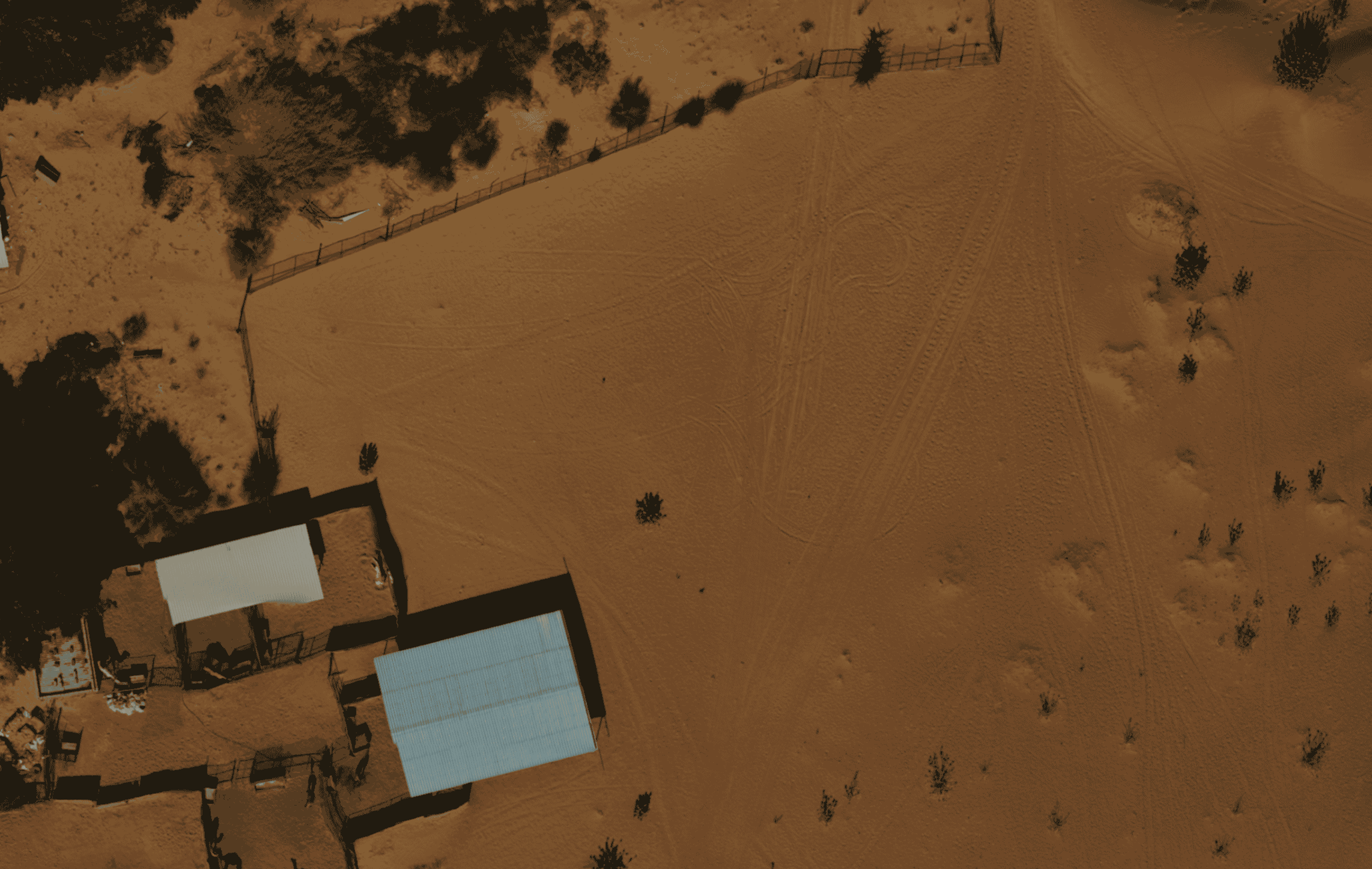
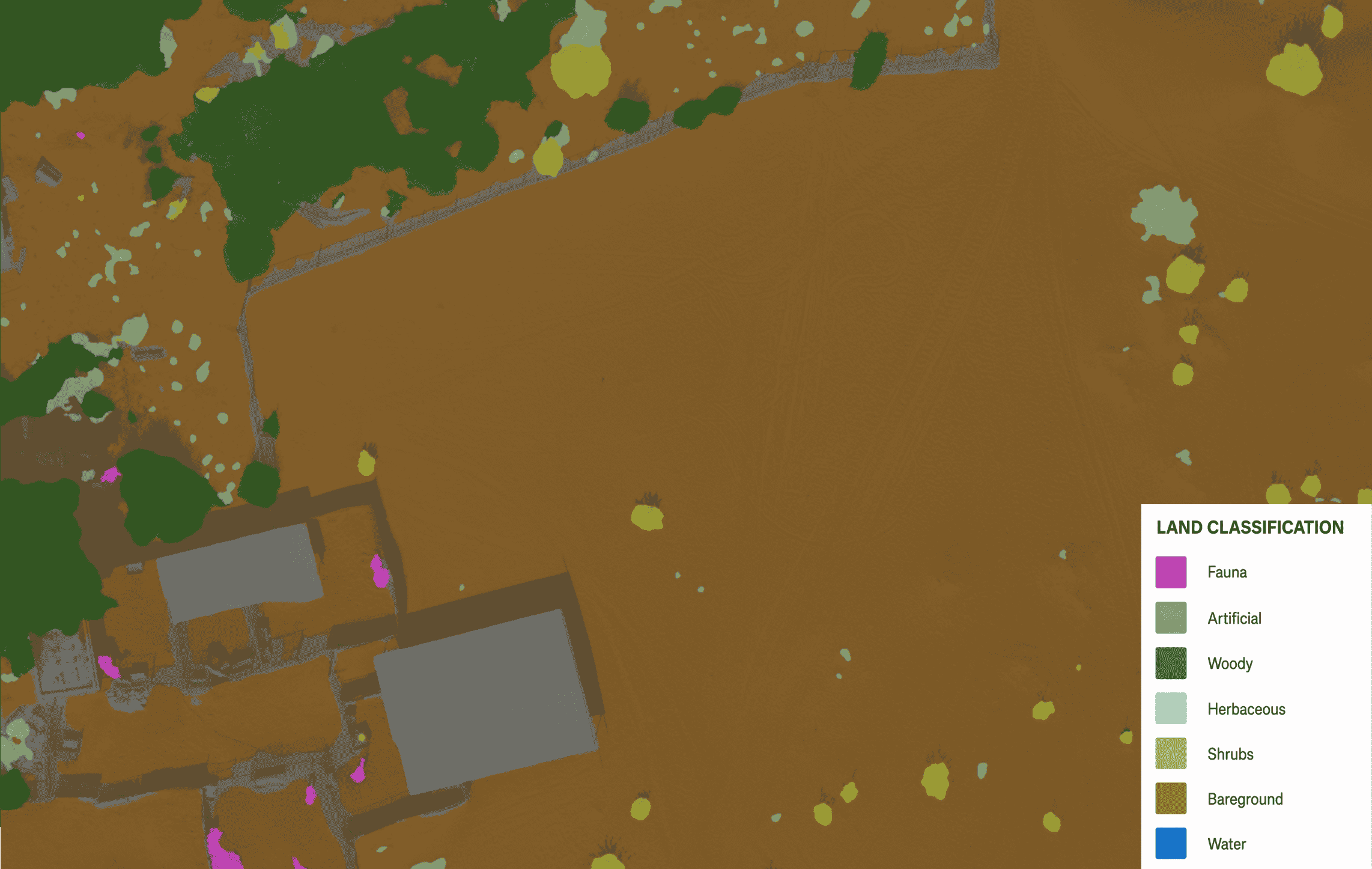
Nabat's dryland land cover classification model applied to a farm compound, identifying buildings, roads, trees, shrubs, and base sand, and revealing the mosaic of human-modified features and natural vegetation withing the surrounding desert environment.
These systems also support more life than they initially reveal. Insects, reptiles, small mammals, and bird species rely on even sparse vegetation for shelter, temperature regulation, and food sources. In this context, grazing plays an important role - when balanced, it remains part of the natural system, but when unmanaged, it can accelerate vegetation loss and push already fragile landscapes beyond their recovery threshold.
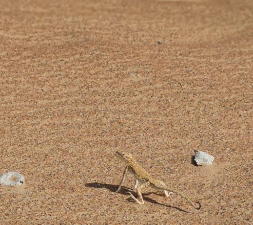
An Arabian toad-headed agama (Phrynocephalus arabicus), captured by one of our field ecologists during a field survey.
There is an honesty required when talking about dryland monitoring: collecting data in these environments is genuinely hard. The terrain is physically demanding, access is often limited, and the scale of the areas involved makes traditional field surveys slow and incomplete. This is where remote sensing becomes not just useful, but necessary. High - resolution imagery, captured through drones or satellites, allows for consistent monitoring across large areas - revealing subtle changes that would otherwise be missed entirely.
At Nabat, we are investing in the capabilities that make this possible at meaningful scale. Today, our teams support monitoring, restoration, and ecosystem management programs across tens of thousands of hectares of landscapes throughout the region. At that scale, relying solely on field surveys becomes increasingly difficult, making high - quality remote sensing an operational necessity rather than a convenience.
Our move toward eVTOL fixed - wing platform - reflects a shift in how we approach data collection in challenging environments. Where a multi-rotor drone might cover 250 hectares in a day, requiring multiple flights and significant operational overhead, we can now cover more than 500 hectares in a single sortie, with sub-centimetre resolution imagery that captures the fine-grained texture of a landscape in enough detail to distinguish between vegetation types, surface conditions, and early signs of stress.
In environments where resources are already scarce and conditions are unforgiving, the ability to do more with less time in the field is not a technical footnote-it is what makes monitoring viable at the scale that restoration programs require. Satellite imagery extends this further still, providing landscape-level continuity between drone surveys and allowing change to be tracked across seasons and years without the logistical demands of repeated ground access.
Once the landscape is mapped with this level of detail, a new set of questions begins to emerge. Where could vegetation exist, but doesn't yet? Where are conditions already stable enough to support recovery? And where have interventions taken hold?
By analyzing patterns across the classified landscape-proximity to existing vegetation, surface stability, and subtle indicators of moisture-it becomes possible to identify areas with a higher likelihood of supporting restoration successfully. This shifts intervention from broad application to something more targeted and informed. In environments where the margin for error is narrow, that precision is not a luxury-it is what separates efforts that persist from efforts that do not.
At the same time, consistent monitoring creates a record-one that shows, over time, where vegetation has stabilized, where growth has compounded, and where, despite the best intentions, conditions simply could not sustain the change.
Those outcomes, including the difficult ones, are often the most valuable. Understanding why vegetation failed to establish can be just as important as understanding why it succeeded. Over time, these observations build a more honest picture of the landscape and allow future interventions to become increasingly precise. They inform better site selection, improve intervention design, and build a more grounded understanding of what recovery looks like in landscapes this demanding.
This monitoring and classification work lays the foundation for restoration in dryland environments, reflecting the understanding that knowing a landscape and acting within it are not separate activities-they are part of the same process.
In this region, the urgency is particular. These landscapes are under compound pressure-from accelerating climate shifts, ongoing development, and a long history of land use that has, in some areas, pushed vegetation cover to its limits. The signals of stress in dryland systems are often gradual and easy to miss, until recovery becomes significantly harder. That is exactly the kind of change that consistent, high-resolution monitoring is designed to detect early.
There is also something worth recognizing in what these landscapes represent. Dryland ecosystems in the Gulf are not empty spaces waiting to be restored. They are culturally significant, ecologically functional, and capable of more resilience than they are often given credit for. Even small gains matter here-a patch of vegetation stabilizing soil, a cluster of plants creating the conditions for other life to return, early signals of recovery where none existed before.
These are not dramatic transformations. They are the kind of quiet, incremental changes that only become visible when you are paying close attention over a long enough period.
What this work has reinforced is that dryland environments deserve the same level of attention, rigor, and investment in understanding as any other ecosystem. The fact that they have often been left out of restoration-focused technology is not a reflection of their importance-it is a gap, and one that is increasingly possible to close.
Because the better we can represent complexity, the better we can respond to it. The more clearly, we can track change over time, the more confidently we can say-not just where vegetation exists, but how it is behaving, what it needs, and what role we are playing in its recovery.
In environments where resources are scarce, every observation counts. Every data point improves how we act. And every small sign of recovery, measured carefully and honestly, is evidence that the effort is worth making.
That makes it worth measuring-and worth protecting.
As restoration programs continue to expand across the Gulf, the challenge is no longer simply planting more vegetation. It is understanding where interventions are most likely to succeed, how ecosystems are changing through time, and how impact can be measured with confidence. If you are working in restoration, conservation, land management, or environmental stewardship, we would love to continue the conversation and explore what better ecosystem intelligence can unlock.
This is part of AI with Muddy Boots, our series on what it takes to understand and restore the ecosystems we work in. Follow along for more, and reach out to our team of restoration, ecology, and technology experts to discuss what this could look like across your landscape and programs.