%20--%3e%3cg%3e%3cg%20id='Layer_1'%3e%3cg%3e%3cg%3e%3cg%3e%3cg%3e%3cpath%20class='cls-1'%20d='M54.7,12.3c-1.4-1-3.3-1.6-5.5-1.6s-4.1.5-5.5,1.6c-1.7,1.2-2.5,2.9-2.5,5v11.8h5v-11.8c0-.4.1-.7.5-.9.6-.4,1.4-.6,2.6-.6s2,.2,2.6.6c.3.2.4.5.4.9v9.8c0,.5.2,1,.6,1.4.4.4.8.6,1.4.6h3v-11.8c0-2.1-.8-3.7-2.5-5Z'/%3e%3cpath%20class='cls-1'%20d='M75.4,11.1c-1,0-1.9.4-2.5,1.1-1.5-1.1-3.4-1.6-5.5-1.5s-4.4,1.1-6,2.7-2.7,4-2.7,6.5,1,4.9,2.7,6.7,4,2.7,6.6,2.7,3.4-.5,4.8-1.5c.6.7,1.4,1.1,2.5,1.1h1.7V11.1h-1.7ZM71.2,23.2c-.9.9-1.9,1.3-3.2,1.3s-2.3-.5-3.1-1.3-1.2-1.8-1.2-3,.4-2.3,1.2-3.1,1.9-1.3,3.1-1.3,2.2.4,3.1,1.3c.9.9,1.3,1.9,1.3,3.1s-.4,2.2-1.3,3.1h0Z'/%3e%3cpath%20class='cls-1'%20d='M89.5,10.7c-1.5,0-2.8.3-4,1v-6.8h-5v24.1h1.7c1,0,1.9-.4,2.5-1.1,1.5,1.1,3.2,1.6,5.2,1.5s4.7-1.1,6.3-2.8,2.7-4,2.7-6.5-.9-4.8-2.7-6.6c-1.8-1.8-4-2.7-6.6-2.7ZM92.6,23.2c-.9.9-1.9,1.3-3.1,1.3s-2.3-.5-3.1-1.3-1.3-1.9-1.3-3.1.5-2.3,1.3-3.1,1.9-1.3,3.1-1.3,2.3.5,3.1,1.3,1.3,1.9,1.3,3.1-.5,2.3-1.3,3.1Z'/%3e%3cpath%20class='cls-1'%20d='M116.3,11.1c-1,0-1.9.4-2.5,1.1-1.5-1.1-3.4-1.6-5.5-1.5s-4.4,1.1-6,2.7-2.7,4-2.7,6.5,1,4.9,2.7,6.7,4,2.7,6.6,2.7,3.4-.5,4.8-1.5c.6.7,1.4,1.1,2.5,1.1h1.7V11.1h-1.7ZM112.1,23.2c-.9.9-1.9,1.3-3.2,1.3s-2.3-.5-3.1-1.3-1.2-1.8-1.2-3,.4-2.3,1.2-3.1,1.9-1.3,3.1-1.3,2.2.4,3.1,1.3c.9.9,1.3,1.9,1.3,3.1s-.4,2.2-1.3,3.1h0Z'/%3e%3cpath%20class='cls-1'%20d='M157.2,11.1c-1,0-1.9.4-2.5,1.1-1.5-1.1-3.4-1.6-5.5-1.5s-4.4,1.1-6,2.7c-1.8,1.8-2.7,4-2.7,6.5s1,4.9,2.7,6.7,4,2.7,6.6,2.7,3.4-.5,4.8-1.5c.6.7,1.4,1.1,2.5,1.1h1.7V11.1h-1.7ZM153,23.2c-.9.9-1.9,1.3-3.2,1.3s-2.3-.5-3.1-1.3-1.2-1.8-1.2-3,.4-2.3,1.2-3.1,1.9-1.3,3.1-1.3,2.2.4,3.1,1.3c.9.9,1.3,1.9,1.3,3.1s-.4,2.2-1.3,3.1h0Z'/%3e%3cpath%20class='cls-1'%20d='M164.6,10.6c.8,0,1.5-.3,2.1-.9.6-.6.9-1.3.9-2.1s-.3-1.5-.9-2.1c-.6-.6-1.3-.9-2.1-.9s-1.5.3-2.1.9c-.6.6-.9,1.3-.9,2.1s.3,1.5.9,2.1c.6.6,1.3.9,2.1.9Z'/%3e%3c/g%3e%3cpath%20class='cls-1'%20d='M130.2,24c0,0-.2,0-.2.1-.3.2-1.8.3-2.3.3s-1.1-.1-1.4-.4c-.2-.2-.3-.6-.3-1.2v-6.8h2.4c.5,0,1-.2,1.4-.6.4-.4.6-.8.6-1.4v-3h-4.3v-1.6c0-.5-.1-1-.4-1.4-.7-1.1-1.7-1.6-2.8-1.6h-1.7v16.4c0,1.9.6,3.5,1.9,4.7,1.2,1.2,2.8,1.8,4.8,1.8s1.8,0,2.6-.2v-5.3Z'/%3e%3c/g%3e%3crect%20class='cls-1'%20x='162'%20y='11.6'%20width='5'%20height='17.6'/%3e%3cpath%20class='cls-1'%20d='M139.6,26.1c0,1.8-1.5,3.3-3.3,3.3s-2.6-.2-2.8-.2c0,0-.5-2.2-.5-3.1,0-1.8,1.5-3.3,3.3-3.3s2.8.1,3,.4c.2.4.4,2,.4,3Z'/%3e%3c/g%3e%3cpath%20class='cls-1'%20d='M29.3,17.5c-1.9,0-3.5,1.3-3.9,3h-.3c-2.8,0-5.3,1.2-7,3.1v-4.9c0-3.3.5-4.5,3.2-4.6.5,1.6,2,2.7,3.8,2.7s4-1.8,4-4-1.8-4-4-4-3.3,1.2-3.8,2.9c-1.3,0-2.3.3-3.1.7v-4.6c1.6-.5,2.7-2,2.7-3.8S19,.2,16.8.2s-4,1.8-4,4,1.2,3.3,2.9,3.8v4.6c-.8-.5-1.9-.7-3.3-.8-.5-1.7-2-2.9-3.8-2.9s-4,1.8-4,4,1.8,4,4,4,3.2-1.1,3.8-2.7c0,0,0,0,0,0,2.8,0,3.3,1.1,3.3,4.6v4.9c-1.7-1.9-4.2-3.1-7-3.1h-.7c-.4-1.7-2-3-3.9-3S0,19.3,0,21.5s1.8,4,4,4,3.1-1,3.7-2.5h.9c3.9,0,7,3.1,7,7v1.6h-4.2c-.7,0-1.2.5-1.2,1.2s.5,1.2,1.2,1.2h10.9c.7,0,1.2-.5,1.2-1.2s-.5-1.2-1.2-1.2h-4.2v-1.6c0-3.9,3.2-7,7-7h.5c.6,1.5,2,2.5,3.7,2.5s4-1.8,4-4-1.8-4-4-4ZM25,11.4c.9,0,1.6.7,1.6,1.6s-.7,1.6-1.6,1.6-1.6-.7-1.6-1.6.7-1.6,1.6-1.6ZM8.6,14.5c-.9,0-1.6-.7-1.6-1.6s.7-1.6,1.6-1.6,1.6.7,1.6,1.6-.7,1.6-1.6,1.6ZM4.1,23.1c-.9,0-1.6-.7-1.6-1.6s.7-1.6,1.6-1.6,1.6.7,1.6,1.6-.7,1.6-1.6,1.6ZM16.8,5.7c-.9,0-1.6-.7-1.6-1.6s.7-1.6,1.6-1.6,1.6.7,1.6,1.6-.7,1.6-1.6,1.6ZM29.3,23.1s0,0,0,0c0,0,0,0,0,0,0,0-.1,0-.2,0,0,0,0,0,0,0-.8-.1-1.3-.8-1.3-1.5s.6-1.5,1.4-1.6c0,0,0,0,0,0,0,0,0,0,0,0s0,0,0,0c0,0,0,0,0,0,.9,0,1.6.7,1.6,1.6s-.7,1.6-1.6,1.6Z'/%3e%3c/g%3e%3c/g%3e%3c/g%3e%3c/svg%3e)

Overview
Healthy coastal ecosystems are fundamental to biodiversity, climate resilience, and sustainable development. Yet identifying the most suitable areas for restoration requires the ability to process and interpret vast volumes of environmental and geospatial data.
To support a coastal environmental assessment project in the Kingdom of Saudi Arabia, Nabat partnered with a regional environmental technology company to run the assessment on NabatOS, Nabat's end-to-end ecosystem management platform, turning environmental and geospatial data into restoration-ready intelligence.
The Challenge
The project aimed to assess coastal environments to support nature conservation and identify areas with potential for future mangrove restoration.
Achieving this required more than traditional mapping. Large and complex geospatial datasets needed to be analysed, interpreted, and presented in a way that would enable technical teams and project stakeholders to make informed decisions efficiently.
The challenge was to transform environmental data into clear, actionable intelligence that could support both project execution and long-term restoration planning.
Nabat's Solution
Nabat delivered the assessment through NabatOS, its end-to-end platform for ecosystem management, combining AI, geospatial analytics and field ecology in one system.
The project included:
- AI-powered land cover classification to improve environmental mapping.
- Advanced geospatial analytics to assess coastal conditions and ecosystem characteristics.
- NabatOS, the interactive platform teams used to explore assessment layers and project outputs in one place.
- A preliminary assessment identifying areas with potential for future mangrove plantation.
By bringing these capabilities together, Nabat enabled project teams to access environmental insights through an intuitive digital platform, making complex geospatial information easier to interpret, communicate, and apply.
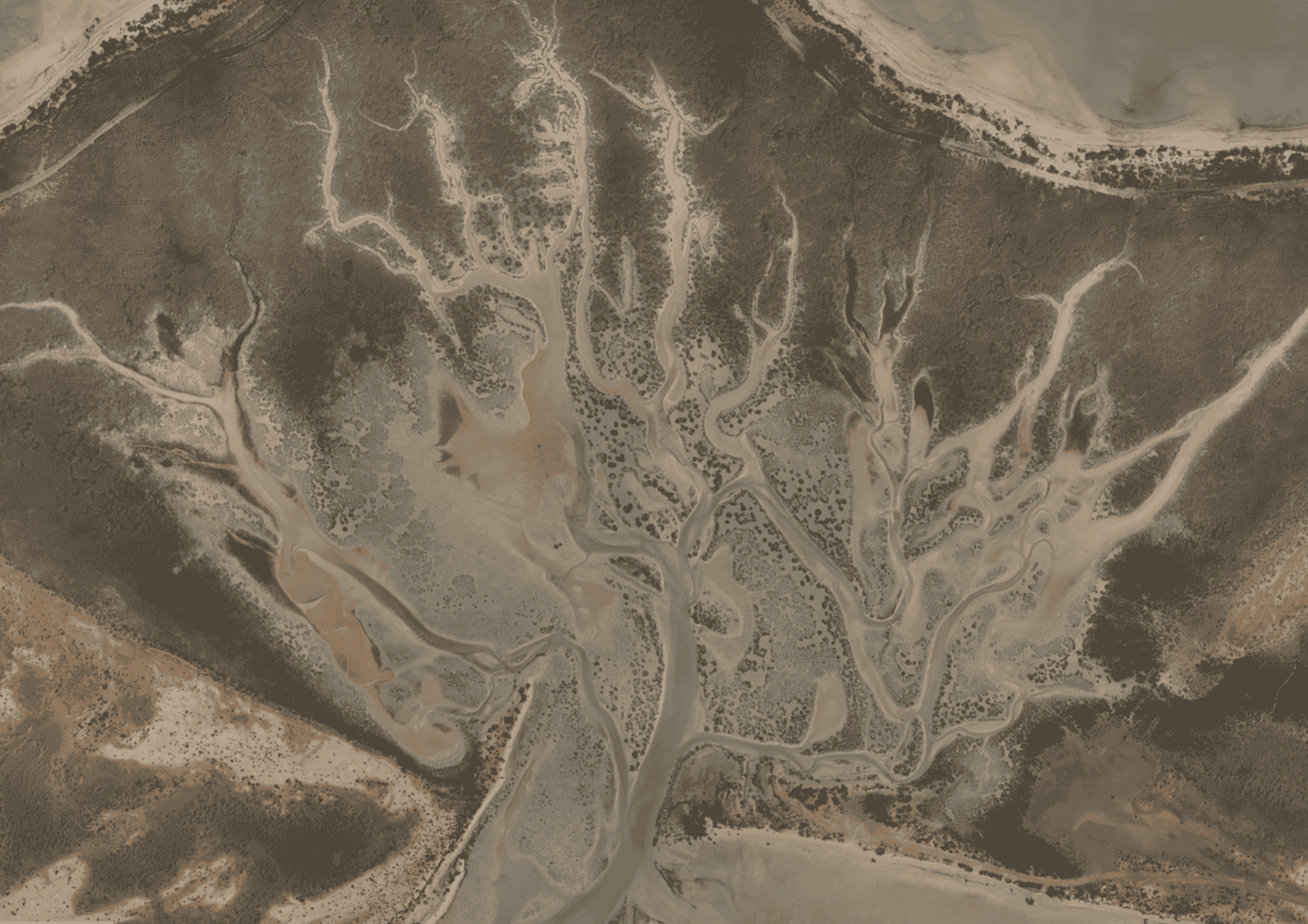
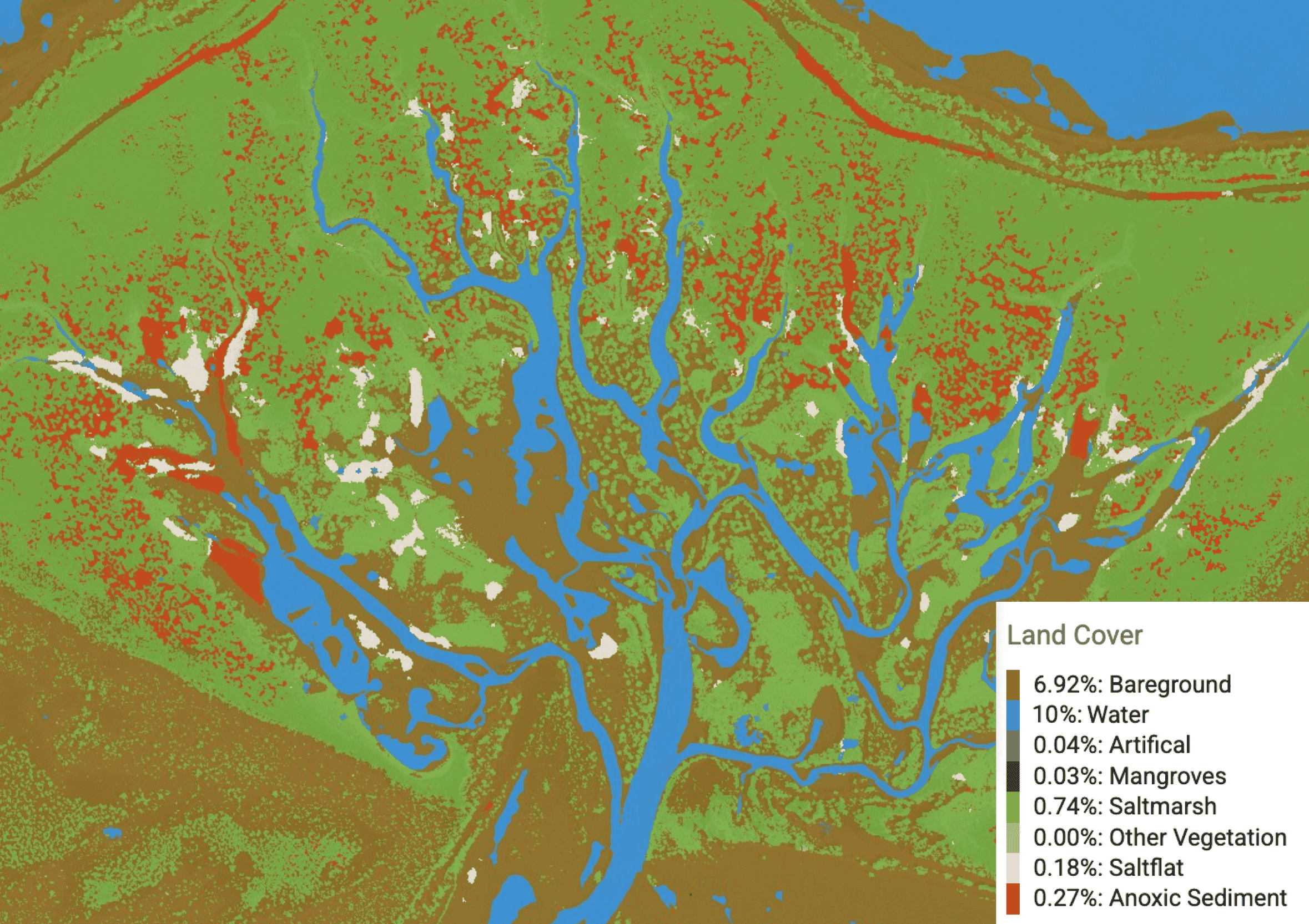
Aerial views showing Nabat's AI-powered land cover classification (right) and natural RGB imagery (left), demonstrating how NabatOS transforms data into actionable intelligence for ecosystem restoration planning.
The Impact
NabatOS turned the project's environmental datasets into verified, traceable outputs the team could act on, strengthening both delivery and stakeholder confidence.
Across the three study sites, the assessment analyzed a total area of approximately 3,422 ha, identifying 187.55 ha as potentially suitable for mangrove reforestation/afforestation. Model performance averaged 94.69% accuracy, validated across 1,800 quadrat-based quality-control cells.
The combination of AI-driven analysis, geospatial expertise, and intuitive visualisation strengthened decision-making throughout the assessment process while providing a foundation for future ecosystem restoration initiatives.
Beyond the technical deliverables, the collaboration demonstrated how intelligent environmental data can help organisations accelerate conservation planning and improve the quality of environmental decision-making.
Partner Perspective
"Nabat transformed complex geospatial datasets into meaningful insights through an intuitive and well-structured platform. Their technical expertise, collaborative approach, and high-quality deliverables contributed significantly to the successful execution of the project."
Looking Ahead
As investment in nature-based solutions continues to grow across the region, environmental intelligence is becoming an essential tool for informed planning and sustainable development.
Nabat continues to help governments, organisations, and environmental partners unlock the value of geospatial data through AI-powered technologies that support ecosystem monitoring, restoration planning, and evidence-based environmental decision-making.